Volcano earthquake report for Saturday, 16 Jan 2021

World map showing volcanoes with shallow (less than 20 km) earthquakes within 20 km radius during the past 24 hours on 16 Jan 2021 Number in brackets indicate nr of quakes.

World map showing volcanoes with shallow (less than 20 km) earthquakes within 20 km radius during the past 24 hours on 16 Jan 2021 Number in brackets indicate nr of quakes.

Quakes detected near: Askja (4 quakes between mag 0.1-1.1), Biliran (1 quake mag 3.0), Buzzard Creek (1 quake mag 2.0), Clear Lake (20 quakes between mag 0.3-1.7), Coso (5 quakes between mag 0.4-1.4), Etna (13 quakes between mag 1.3-2.1)
Fourpeaked (1 quake mag 1.6), Grímsnes (2 quakes between mag 0.6-1.7), Hekla (20 quakes between mag 0.3-2.5), Katla (3 quakes between mag 0.5-1.4), Krísuvík (11 quakes between mag 0.3-1.7), Long Valley (2 quakes between mag 1.8-2.3), Mount Rainier (1 quake mag 2.4), Reykjanes (8 quakes between mag 0.1-1.4), Salton Buttes (1 quake mag 1.3), Serdán-Oriental (1 quake mag 3.4), Taupo (1 quake mag 1.5), Tenerife (1 quake mag 1.4), Tongariro (1 quake mag 1.0), Turrialba (1 quake mag 3.1), Wide Bay (1 quake mag 1.1) (updated 02h50)

Note: Earthquakes within 20 km from and at depths less than 20 km under active volcanoes are reported. The list is not complete because many volcanoes are not monitored and/or seismic data in high resolution is not available publicly.

Volcanoes with recent earthquakes above magnitude 2 or more than 10 quakes are listed below:

Biliran volcano (Central Philippines): magnitude 3.0 earthquake

A magnitude 3.0 earthquake occurred at the volcano 52 minutes ago. The quake, which might be volcanic in origin, was located at a depth of 1.0 km depth at 18 km distance S from the volcano.
Earthquake details:
3.0 quake Philippines Sea, 5.7 km northwest of Pinamopoan, Leyte, Eastern Visayas, Philippines, 16 Jan 2021 9:58 am (GMT +8) (18 km S)All earthquakes at Biliran

Clear Lake volcano (California): 20 earthquakes up to magnitude 1.7

Possible earthquake swarm: 20 earthquakes occurred near (under) the volcano during 21 hours, the last being recorded quake 1 hour 53 minutes ago. Hypocenter depths ranged between 3.2 and 0.3 km.
Earthquake details: (only 5 largest)
1.7 quake 8.8 mi east of Cloverdale, Sonoma County, California, USA, 15 Jan 2021 8:26 am (GMT -8) (18 km SSW)1.3 quake 6km WNW of Cobb, CA, USA, 15 Jan 2021 3:58 pm (GMT -8) (15 km S)1.3 quake 4.2 mi west of Cobb, Lake County, California, USA, 15 Jan 2021 6:34 am (GMT -8) (17 km S)1.2 quake 2.1 mi west of Cobb, Lake County, California, USA, 15 Jan 2021 12:21 pm (GMT -8) (17 km S)1.2 quake 3.1 mi southwest of Cobb, Lake County, California, USA, 15 Jan 2021 12:00 pm (GMT -8) (19 km S)All earthquakes at Clear Lake

Etna volcano (Italy): 13 earthquakes up to magnitude 2.1

Possible earthquake swarm: 13 earthquakes occurred near (under) the volcano during 18 hours, the last being recorded quake 6 hours ago. Hypocenter depths ranged between 3.8 and 0.5 km.
Earthquake details: (only 5 largest)
2.1 quake 12 km northwest of Zafferana Etnea, Catania, Sicily, Italy, 15 Jan 2021 1:55 pm (GMT +1) (1 km ENE)1.8 quake 14 km west of Giarre, Catania, Sicily, Italy, 15 January 2021 09:45 GMT (2 km ESE)1.6 quake 15 km east of Bronte, Catania, Sicily, Italy, 15 Jan 2021 9:59 pm (GMT +1) (1 km E)1.6 quake 16 km west of Giarre, Catania, Sicily, Italy, 15 Jan 2021 6:55 am (GMT +1) (1 km ENE)1.6 quake 16 km west of Giarre, Catania, Sicily, Italy, 15 Jan 2021 4:48 am (GMT +1) (1 km ENE)All earthquakes at Etna

Hekla volcano (Iceland): 20 earthquakes up to magnitude 2.5

Possible earthquake swarm: 20 earthquakes occurred near (under) the volcano during 11 hours, the last being recorded quake 1 hour 14 minutes ago. Hypocenter depths ranged between 8.8 and 5.6 km.
Earthquake details: (only 5 largest)
2.5 quake 15.4 Km SE of Árnes, Iceland, 15 Jan 2021 2:21 pm (GMT +0) (17 km WSW)2.2 quake 15.4 Km SE of Árnes, Iceland, 15 Jan 2021 2:12 pm (GMT +0) (17 km WSW)1.5 quake 15.4 Km SE of Árnes, Iceland, 15 Jan 2021 3:08 pm (GMT +0) (16 km WSW)1.5 quake 15.4 Km SE of Árnes, Iceland, 15 Jan 2021 2:16 pm (GMT +0) (17 km WSW)1.4 quake 15.3 Km SE of Árnes, Iceland, 15 Jan 2021 2:23 pm (GMT +0) (17 km WSW)All earthquakes at Hekla

Krísuvík volcano (Iceland): 11 earthquakes up to magnitude 1.7

Possible earthquake swarm: 11 earthquakes occurred near (under) the volcano during 18 hours, the last being recorded quake 1 hour 40 minutes ago. Hypocenter depths ranged between 10.0 and 5.6 km.
Earthquake details: (only 5 largest)
1.7 quake 4.0 Km S of Keilir, Iceland, 15 Jan 2021 9:59 am (GMT +0) (5 km WSW)1.0 quake 0.4 Km E of Fagradalsfjall, Iceland, 15 January 2021 06:48 GMT (9 km WSW)0.9 quake 1.0 Km SE of Fagradalsfjall, Iceland, 15 January 2021 09:30 GMT (9 km WSW)0.9 quake 4.4 Km ESE of Fagradalsfjall, Iceland, 15 January 2021 10:11 GMT (6 km SW)0.8 quake 5.4 Km WSW of Krýsuvík, Iceland, 15 Jan 2021 2:41 pm (GMT +0) (7 km SSW)All earthquakes at Krísuvík

Long Valley volcano (California): 2 earthquakes up to magnitude 2.3

2 earthquakes occurred near (under) the volcano during 2 hours, the last being recorded quake 1 hour 57 minutes ago. Hypocenter depths ranged between 6.2 and 6.1 km.
Earthquake details:
2.3 quake 11km E of Mammoth Lakes, CA, USA, 15 Jan 2021 4:53 pm (GMT -8) (8 km SSE)1.8 quake 6.9 mi east of Mammoth Lakes, Mono County, California, USA, 15 Jan 2021 2:51 pm (GMT -8) (7 km SSE)All earthquakes at Long Valley

Mount Rainier volcano (Washington): magnitude 2.4 earthquake

A magnitude 2.4 earthquake occurred at the volcano 17 hours ago. The quake, which might be volcanic in origin, was located at a depth of 13.3 km depth at 16 km distance WNW from the volcano.
Earthquake details:
2.4 quake 19 mi southeast of Prairie Ridge, Pierce County, Washington, USA, 15 Jan 2021 2:06 am (GMT -8) (16 km WNW)All earthquakes at Mount Rainier

Serdán-Oriental volcano (Western & Central Mexico): magnitude 3.4 earthquake

A magnitude 3.4 earthquake occurred at the volcano 7 hours ago. The quake, which might be volcanic in origin, was located at a depth of 10.0 km depth at 8 km distance ESE from the volcano.
Earthquake details:
3.4 quake San José Capilla, 8.3 km southwest of Guadalupe Victoria, Puebla, Mexico, 2021-01-15 13:44:44 (Hora de México) (8 km ESE)All earthquakes at Serdán-Oriental

Turrialba volcano (Costa Rica): magnitude 3.1 earthquake

A magnitude 3.1 earthquake occurred at the volcano 20 hours ago. The quake, which might be volcanic in origin, was located at a depth of 3.0 km depth at 1 km distance NNE from the volcano.
Earthquake details:
3.1 quake 18 km northwest of Turrialba, Provincia de Cartago, Costa Rica, 15 Jan 2021 12:21 am (GMT -6) (1 km NNE)All earthquakes at Turrialba

Light magnitude 4.8 earthquake 11 km southwest of Calaca, Philippines

4.8 quake 16 Jan 6:48 am (GMT +8)

An earthquake of magnitude 4.8 occurred early morning on Saturday 16 January 2021 at 6:48 am local time near Calaca, Province of Batangas, Calabarzon, Philippines, as reported by the German Research Centre for Geosciences (GFZ).
According to preliminary data, the quake was located at an intermediate to considerable depth of 185 km. The strength of the earthquake may have been tempered by its relative great depth below the surface, which makes it feel weaker in absolute terms. The exact magnitude, epicenter, and depth of the quake might be revised within the next few hours or minutes as seismologists review data and refine their calculations, or as other agencies issue their report.
Our monitoring service identified a second report from the Philippine Institute of Volcanology and Seismology (PHIVOLCS) which listed the quake at magnitude 4.5. A third agency, the European-Mediterranean Seismological Centre (EMSC), reported the same quake at magnitude 4.5.
Towns or cities near the epicenter where the quake might have been felt as very weak shaking include Hukay (pop. 2,200) located 8 km from the epicenter, Calaca (pop. 37,400) 11 km away, Balayan (pop. 50,100) 12 km away, Balayan (pop. 50,100) 12 km away, Calatagan (pop. 16,100) 16 km away, Taal (pop. 39,700) 16 km away, Bauan (pop. 33,600) 25 km away, Batangas City (pop. 237,400) 31 km away, Las Piñas (pop. 590,000) 71 km away, and Manila (pop. 1,600,000) 88 km away.
VolcanoDiscovery will automatically update magnitude and depth if these change and follow up if other significant news about the quake become available. If you’re in the area, please send us your experience through our reporting mechanism, either online or via our mobile app. This will help us provide more first-hand updates to anyone around the globe who wants to know more about this quake.

Earthquake data:
Date & time: 16 Jan 2021 6:48 am (GMT +8) local time (15 Jan 2021 22:48 GMT)
Magnitude: 4.8
Depth: 185.0 km
Epicenterlatitude / longitude: 13.84°N / 120.78°E (South China Sea, Philippines)
Primary data source: GFZ

Light tremor of magnitude 4.2 just reported 19 km northwest of Volcan Chimborazo, Ecuador

4.2 quake 15 Jan 1:45 pm (GMT -5)

Just 8 minutes ago, a 4.2-magnitude earthquake struck near Volcan Chimborazo, Cantón Esmeraldas, Provincia de Esmeraldas, Ecuador. The tremor was recorded around noon on Friday 15 January 2021 at 1:45 pm local time, at a very shallow depth of 5 km below the surface.
The event was filed by the Institute of Geophysics of the National Polytechnic School in Quito (IGEPN), the first seismological agency to report it.
A second report was later issued by the European-Mediterranean Seismological Centre (EMSC), which listed it as a magnitude 4.2 earthquake as well.
Based on the preliminary seismic data, the quake should not have caused any significant damage, but was probably felt by many people as light vibration in the area of the epicenter.
Weak shaking might have been felt in Volcan Chimborazo (pop. 165,200) located 19 km from the epicenter.
Other towns or cities near the epicenter where the quake might have been felt as very weak shaking include Muisne (pop. 13,400) located 68 km from the epicenter.

Earthquake data:
Date & time: 15 Jan 2021 1:45 pm (GMT -5) local time (15 Jan 2021 18:45 GMT)
Magnitude: 4.1
Depth: 2.0 km
Epicenterlatitude / longitude: 1.32°N / 79.87°W (North Pacific Ocean, Ecuador)
Primary data source: IGEPN

World Earthquake Report for Friday, 15 January 2021

Worldwide earthquakes above magnitude 3 during the past 24 hours on 15 Jan 2021

Worldwide earthquakes above magnitude 3 during the past 24 hours on 15 Jan 2021

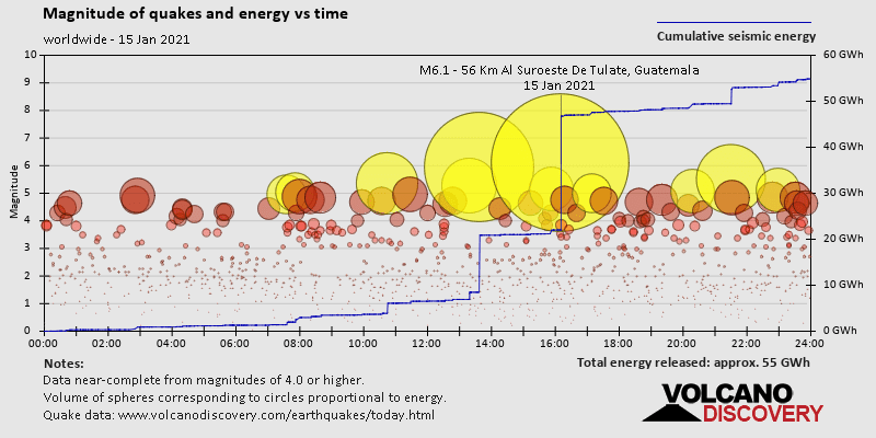
Summary: 1 quake 6.0+, 5 quakes 5.0+, 34 quakes 4.0+, 106 quakes 3.0+, 229 quakes 2.0+ (375 total)
This report is being updated every hour.
Magnitude 6+: 1 earthquake
Magnitude 5+: 5 earthquakes
Magnitude 4+: 34 earthquakes
Magnitude 3+: 106 earthquakes
Magnitude 2+: 229 earthquakes
No quakes of magnitude 7 or higher

10 largest earthquakes in the world (past 24 hours):

#1: 6.2 quake 34 km south of Mamuju, Kabupaten Mamuju, West Sulawesi, Indonesia, 15 Jan 2021 2:28 am (GMT +8)
#2: 5.9 quake Philippines Sea, 89 km southeast of Ise, Ise-shi, Mie, Japan, 15 Jan 2021 10:38 pm (GMT +9)
#3: 5.4 quake South Atlantic Ocean 15 Jan 2021 9:45 am (GMT -1)
#4: 5.3 quake South Atlantic Ocean 15 Jan 2021 12:19 pm (GMT -1)
#5: 5.0 quake South Pacific Ocean, 1393 km southwest of Santiago, Provincia de Santiago, Santiago Metropolitan, Chile, 14 Jan 2021 10:45 am (GMT -5)
#6: 5.0 quake South Atlantic Ocean, 2266 km south of Jamestown, Half Tree Hollow, Sainte Helene, St. Helena, 15 Jan 2021 6:36 am (GMT -1)
#7: 4.9 quake 8.1 km southwest of Novokuznetsk, Kemerovo Oblast, Russia, 15 Jan 2021 9:55 am (GMT +7)
#8: 4.9 quake South Atlantic Ocean 15 Jan 2021 6:52 am (GMT -1)
#9: 4.9 quake 81 km southeast of Mezhdurechensk, Kemerovo Oblast, Russia, 15 Jan 2021 2:59 pm (GMT +7)
#10: 4.8 quake Buryatiya Republic, 45 km northwest of Turt, Khankh, Hövsgöl Aymag, Mongolia, 15 Jan 2021 4:26 am (GMT +8)

Earthquakes reported felt:

#1: 2.6 quake 2.6 km northeast of Roetgen, Cologne District, North Rhine-Westphalia, Germany, 14 Jan 2021 7:06 pm (GMT +1) – 327 reports
#2: 3.5 quake 4.1 km northwest of Glenorchy, Northern Grampians, Victoria, Australia, 15 Jan 2021 7:58 am (GMT +11) – 124 reports
#3: 4.2 quake Grad Glina, Sisak-Moslavina, 2.9 km south of Hotnja, Pokupsko, Zagreb County, Croatia, 15 Jan 2021 1:01 pm (GMT +1) – 101 reports
#4: 4.0 quake 5.1 mi east of Pāhala, Hawaii County, USA, 14 Jan 2021 6:15 pm (GMT -10) – 62 reports
#5: 3.6 quake 1 mile west of Concord, Contra Costa County, CA, USA, 14 Jan 2021 11:18 am (GMT -8) – 55 reports
#6: 2.7 quake 9 km south of Stolberg, Cologne District, North Rhine-Westphalia, Germany, 14 Jan 2021 7:06 pm (GMT +1) – 18 reports
#7: 4.1 quake 1.2 km northwest of Donje Taborište, Grad Glina, Sisak-Moslavina, Croatia, 15 Jan 2021 1:01 pm (GMT +1) – 13 reports
#8: 6.2 quake 34 km south of Mamuju, Kabupaten Mamuju, West Sulawesi, Indonesia, 15 Jan 2021 2:28 am (GMT +8) – 11 reports
#9: 2.9 quake 1 km northwest of Volavje, Grad Jastrebarsko, Zagreb County, Croatia, 15 Jan 2021 2:50 am (GMT +1) – 9 reports
#10: 2.5 quake 33 km south of Rustenburg, Bojanala Platinum, North West, South Africa, 14 Jan 2021 11:19 pm (GMT +2) – 3 reports
#11: 3.2 quake Courtelary, 2.6 km southeast of Corgémont, Bernese Jura, Switzerland, 15 Jan 2021 2:40 am (GMT +1) – 3 reports
#12: 5.9 quake Philippines Sea, 89 km southeast of Ise, Ise-shi, Mie, Japan, 15 Jan 2021 10:38 pm (GMT +9) – 2 reports
#13: 2.2 quake 0.4 mi southwest of Concord, Contra Costa County, California, USA, 14 Jan 2021 11:26 am (GMT -8) – 2 reports

Earthquake stats:

Number of quakes and energy vs timeNumber of quakes and energy vs magnitudeMagnitude of quakes and energy vs time

Light magnitude 4.9 quake hits 36 km northwest of Volcan Chimborazo, Ecuador early morning

4.9 quake 15 Jan 5:35 am (GMT -5)

Just 7 minutes ago, a 4.9-magnitude earthquake struck near Volcan Chimborazo, Cantón Esmeraldas, Provincia de Esmeraldas, Ecuador. The tremor was recorded early morning on Friday 15 January 2021 at 5:35 am local time, at a very shallow depth of 5 km below the surface.
The event was filed by the Institute of Geophysics of the National Polytechnic School in Quito (IGEPN), the first seismological agency to report it.
Based on the preliminary seismic data, the quake should not have caused any significant damage, but was probably felt by many people as light vibration in the area of the epicenter.
Weak shaking might have been felt in Volcan Chimborazo (pop. 165,200) located 36 km from the epicenter.
VolcanoDiscovery will automatically update magnitude and depth if these change and follow up if other significant news about the quake become available. If you’re in the area, please send us your experience through our reporting mechanism, either online or via our mobile app. This will help us provide more first-hand updates to anyone around the globe who wants to know more about this quake.

Earthquake data:
Date & time: 15 Jan 2021 5:35 am (GMT -5) local time (15 Jan 2021 10:35 GMT)
Magnitude: 4.9
Depth: 5.0 km
Epicenterlatitude / longitude: 1.26°N / 79.77°W (North Pacific Ocean, Ecuador)
Primary data source: IGEPN