Merapi volcano (Java, Indonesia): dangerous hot avalanches as lava dome continues to grow

Incandescent avalanches from Merapi’s lava dome this evening (image: VSI webcam)

The activity of the volcano is on increasing trend. A first true pyroclastic flow descended this morning from the growing lava dome.

Early this morning at around 5 am local time, a larger rockfall disintegrated into a turbulent and highly mobile mixture of hot rocks, ash particles, and hot gasses, released from from the breaking lava particles,- a glowing avalanche that traveled approx. 1500 m downhill into the Kali Krasak valley. Ash plumes from rising fine material separating from the flow rose about 500 m.

Such avalanches are known by volcanologists under the terms of nuée ardente, block-and-ash flow, pyroclastic flow or pyroclastic density current, and represent the deadliest volcanic hazard of volcanoes such as Merapi, which is a notorious producer of them during most of its eruptions.
While this morning’s flow was still a small one and still stopped relatively far from inhabited areas, the length of such pyroclastic flows can easily reach many kilometers, and larger ones should be expected to occur at any time now.
During the past few days, the new lava dome has been showing intense glow and near-constant incandescent rockfalls, suggesting that the rate of its growth has accelerated. Seismic activity has also shown a strong increase lately, which likely means that more magma is on its way up to the crater and into the dome.

As its mass increases, so does the risk that partial collapses from its sides generate more voluminous rockfalls and increasingly dangerous hot avalanches.

For now, and likely the foreseeable near future, they seem to be confined to emerging from the notch in the southwestern crater walls leading into the deep Krasak ravine. The Krasak valley and its banks are the highest risk zones at the moment.

Time-lapse video of this morning’s pyroclastic flow:

Histogram of seismic activity at Merapi (image: VSI)

World Earthquake Report for Saturday, 16 January 2021

Worldwide earthquakes above magnitude 3 during the past 24 hours on 16 Jan 2021

Worldwide earthquakes above magnitude 3 during the past 24 hours on 16 Jan 2021

Summary: 1 quake 6.0+, 10 quakes 5.0+, 42 quakes 4.0+, 123 quakes 3.0+, 237 quakes 2.0+ (413 total)
This report is being updated every hour.
Magnitude 6+: 1 earthquake
Magnitude 5+: 10 earthquakes
Magnitude 4+: 42 earthquakes
Magnitude 3+: 123 earthquakes
Magnitude 2+: 237 earthquakes
No quakes of magnitude 7 or higher

10 largest earthquakes in the world (past 24 hours):

#1: 6.1 quake North Pacific Ocean, 57 km southwest of Champerico, Departamento de Retalhuleu, Guatemala, 15 Jan 2021 10:10 am (GMT -6)
#2: 5.5 quake 60 km northeast of Bandar-e Lengeh, Hormozgan, Iran, 16 Jan 2021 1:01 am (GMT +3:30)
#3: 5.5 quake North Pacific Ocean, 471 km southwest of Panama City, 16 Jan 2021 12:18 am (GMT -5)
#4: 5.3 quake Indian Ocean, 96 km southwest of Pulau Betuah Island, Lampung, Indonesia, 16 Jan 2021 4:26 pm (GMT +7)
#5: 5.2 quake South Pacific Ocean, 61 km east of Pangai, Ha‘apai, Tonga, 16 Jan 2021 7:36 pm (GMT +13)
#6: 5.1 quake Bismarck Sea, 713 km northeast of Port Moresby, National Capital, Papua New Guinea, 16 Jan 2021 1:52 am (GMT +10)
#7: 5.1 quake Papua New Guinea 16 Jan 2021 7:18 am (GMT +11)
#8: 5.1 quake Molucca Sea, 56 km north of Pulau Gureda Island, North Maluku, Indonesia, 16 Jan 2021 8:00 am (GMT +9)
#9: 5.1 quake Limarí Province, 50 km south of Ovalle, Provincia de Limari, Coquimbo Region, Chile, 16 Jan 2021 12:53 am (GMT -3)
#10: 5.1 quake 149 km west of Kimbe, Talasea District, West New Britain Province, Papua New Guinea, 16 Jan 2021 4:37 pm (GMT +10)

Earthquakes reported felt:

#1: 6.1 quake North Pacific Ocean, 57 km southwest of Champerico, Departamento de Retalhuleu, Guatemala, 15 Jan 2021 10:10 am (GMT -6) – 36 reports
#2: 3.2 quake Western Mediterranean, 10.1 km north of ’Aïn el Turk, Oran, Algeria, 16 Jan 2021 10:42 am (GMT +1) – 35 reports
#3: 5.5 quake 60 km northeast of Bandar-e Lengeh, Hormozgan, Iran, 16 Jan 2021 1:01 am (GMT +3:30) – 28 reports
#4: 3.3 quake 1.4 km south of Cassà de la Selva, Girona, Catalonia, Spain, 16 Jan 2021 12:40 pm (GMT +1) – 16 reports
#5: 3.3 quake Grad Glina, 23 km west of Sisak, Sisak-Moslavina, Croatia, 16 Jan 2021 10:59 am (GMT +1) – 16 reports
#6: 5.1 quake Limarí Province, 50 km south of Ovalle, Provincia de Limari, Coquimbo Region, Chile, 16 Jan 2021 12:53 am (GMT -3) – 10 reports
#7: 4.6 quake South Pacific Ocean, 91 km south of Lima, Peru, 15 Jan 2021 6:51 pm (GMT -5) – 7 reports
#8: 4.8 quake South China Sea, 10.9 km south of Calaca, Province of Batangas, Calabarzon, Philippines, 16 Jan 2021 6:48 am (GMT +8) – 6 reports
#9: 5.0 quake North Pacific Ocean, 70 km southwest of Usulutan, Departamento de Usulutan, El Salvador, 15 Jan 2021 11:09 am (GMT -6) – 5 reports
#10: 3.9 quake Esmeralda County, 29 mi west of Tonopah, Nye County, Nevada, USA, 15 Jan 2021 7:45 am (GMT -8) – 3 reports
#11: 3.3 quake Persian Gulf, 58 km northwest of Jazīreh-ye Garam Island, Bushehr, Iran, 15 Jan 2021 11:36 pm (GMT +3:30) – 3 reports
#12: 4.7 quake North Pacific Ocean, 59 km southwest of Champerico, Municipio de Champerico, Departamento de Retalhuleu, Guatemala, 15 Jan 2021 10:18 am (GMT -6) – 3 reports
#13: 3.6 quake Aegean Sea, 8.6 km northeast of Kokkari, Samos, North Aegean, Greece, 15 Jan 2021 7:20 pm (GMT +2) – 3 reports
#14: 2.8 quake 0.9 mi north of Blytheville, Mississippi County, Arkansas, USA, 15 Jan 2021 12:17 pm (GMT -6) – 3 reports
#15: 2.4 quake Esmeralda County, 18 mi southeast of Mina, Mineral County, Nevada, USA, 15 Jan 2021 7:56 am (GMT -8) – 2 reports

Earthquake stats:

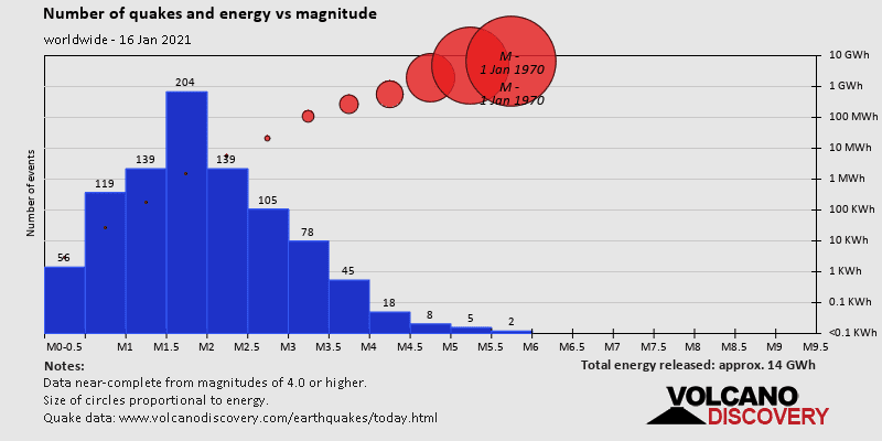
Number of quakes and energy vs timeNumber of quakes and energy vs magnitudeMagnitude of quakes and energy vs time

Small earthquake of magnitude 3.2 just reported 29 miles northeast of Mammoth Lakes, California, United States

3.2 quake 15 Jan 11:16 pm (GMT -8)

An earthquake of magnitude 3.2 occurred only 8 minutes ago 29 miles northeast of Mammoth Lakes, California, United States, the United States Geological Survey (USGS) reported.
The quake hit at a very shallow depth of 0.6 miles beneath the epicenter near Mammoth Lakes, Mono County, California, USA, late at night on Friday 15 January 2021 at 11:16 pm local time. The exact magnitude, epicenter, and depth of the quake might be revised within the next few hours or minutes as seismologists review data and refine their calculations, or as other agencies issue their report.
A second report was later issued by the European-Mediterranean Seismological Centre (EMSC), which listed it as a magnitude 3.5 earthquake.
Towns or cities near the epicenter where the quake might have been felt as very weak shaking include Benton (pop. 280) located 8 miles from the epicenter. In Sunny Slopes (pop. 180, 25 miles away), Mammoth Lakes (pop. 7,900, 29 miles away), Dixon Lane-Meadow Creek (pop. 2,600, 37 miles away), Dixon Lane-Meadow Creek (pop. 2,600, 37 miles away), West Bishop (pop. 2,600, 38 miles away), and Hawthorne (pop. 3,300, 43 miles away), the quake was probably not felt.

Earthquake data:
Date & time: 15 Jan 2021 11:16 pm (GMT -8) local time (16 Jan 2021 07:16 GMT)
Magnitude: 3.2
Depth: 0.9 km
Epicenterlatitude / longitude: 37.91°N / 118.55°W (Mono County, California, United States)
Primary data source: USGS