
Etna (Sicily, Italy): INGV reported that lava effusion had ended on 6 February from the vents at the NE base of Etna’s SE Crater, in the Valle del Leone at about 2,800 m elevation. The total area covered by the lava flows was an estimated 0.96 square kilometers and the estimated volume was 4,800,000-6,100,000 cubic meters. In a Volcano Observatory Notices for Aviation (VONA) posted on 7 February, the Aviation Color Code was lowered to Yellow (the second lowest level om a four-color scale) and INGV noted that although effusion had stopped unrest was ongoing.
In a second VONA, posted on 14 February, the Aviation Color Code was lowered to Green as activity had decreased to background levels.
… [read more]
Shiveluch (Kamchatka): (23 Feb) Explosive activity continues. Volcanic Ash Advisory Center (VAAC) Tokyo warned about a volcanic ash plume that rose up to estimated 15000 ft (4600 m) altitude or flight level 150 and is moving at 10 kts in NE direction.
The full report is as follows: VA AT 20230222/1940Z FL150 EXTD NE OBS VA DTG:22/1940Z to 15000 ft (4600 m)
…23 Feb:
KVERT reported that the ongoing eruption at Sheveluch during 9-16 February was generally characterized by explosions, hot avalanches, lava-dome extrusion, and strong fumarolic activity. A daily thermal anomaly was identified in satellite images. The Aviation Color Code remained at Orange (the second highest level on a four-color scale).
Dates are based on UTC times; specific events are in local time where noted.
… [read more]
Chikurachki (Paramushir Island): KVERT reported that moderate eruptive activity at Chikurachki had ended, with explosions and ash plumes last recorded on 8 February. Steam-and-gas emissions persisted. The Aviation Color Code was lowered to Yellow and then Green (the lowest level on a four-color scale) on 18 February.
Dates are based on UTC times; specific events are in local time where noted.
… [read more]
Ebeko (Paramushir Island): KVERT reported that moderate activity at Ebeko was ongoing during 9-16 February. According to volcanologists in Severo-Kurilsk (Paramushir Island, about 7 km E) explosions during 9 and 12-13 February generated ash plumes that rose as high as 4 km (13,100 ft) a.s.l. and drifted NE and E.
A thermal anomaly was identified in satellite images on 9 and 13 February, and an ash cloud drifted 45 km E on 12 February. The Aviation Color Code remained at Orange (the second highest level on a four-color scale). Dates are based on UTC times; specific events are in local time where noted.
… [read more]
Sakurajima (Kyushu, Japan): JMA reported ongoing eruptive activity at Minamidake Crater (at Aira Caldera’s Sakurajima volcano) during 13-20 February and crater incandescence was visible nightly. Five explosions and five eruptive events were recorded during the week. One of the explosions, at 1448 on 14 February, produced an ash plume that rose 2.4 km above the crater rim and ejected large blocks 1.1 km from the vent.
Blocks 3 cm in diameter fell near the Arimura Lava Observatory in Arimura-cho, Kagoshima City, about 3 km SE. An explosion on 19 February produced an eruption plume that rose 1.2 km and ejected blocks that fell 1.1 km away. A very small eruptive event occurred at Showa Crater on 20 February.
… [read more]
Suwanose-jima (Ryukyu Islands): Volcanic Ash Advisory Center Tokyo (VAAC) issued the following report: ERUPTED AT 20230223/1725Z FL060 EXTD N OBS VA DTG:23/1720Z
…23 Feb:
JMA reported that the eruption at Suwanosejima’s Ontake Crater continued during 13-20 February. Occasional ashfall and rumbling noises were reported in Toshima village (3.5 km SSW). The number of explosions per day increased on 13 February and then gradually decreased beginning on 16 February; a total of about 24 explosions occurred during the week.
At 2131 on 15 February an explosion produced an ash plume that rose 1.3 km above the crater rim and ejected large blocks as far as 900 m SE. An explosion around an hour later, at 2237, ejected large blocks as far as 700 m SE. During 18-20 February explosions produced ash plumes that rose as high as 2 km above the crater rim and ejected large blocks as far as 400 m from the vent.
… [read more]
Karangetang (Siau Island, Sangihe Islands, Indonesia): The effusive eruption at the volcano is slowly but surely intensifying, Andi Volcanist, our expedition leader and guide, reported from field observations.
More and more glowing lava blocks continue to detach from the lava dome within the Crater 1, spreading onto the western and eastern flank, and illuminating mostly the western segment of the edifice.
As seen in the attached image, an impressive insight allows us to observe also a glowing Crater 2 in the background, meaning two craters out of five are active now.
…23 Feb:
According to PVMBG the eruption at Karangetang’s Main Crater (S crater) continued during 14-21 February. Multiple nighttime webcam images posted with daily reports showed three main incandescent lava flows of different lengths descending the S, SW, and W flanks; a webcam image from 2156 on 17 February possibly showed incandescent material descending the SE flank. Incandescent rocks dotted the upper flanks, possibly from ejected or collapsed material from the crater; the incandescence was often most intense at the summit.
Based on analyses of satellite imagery and weather models, the Darwin VAAC reported that during 16-20 February daily ash plume rose to an altitude of 2.1-3 km (7,000-10,000 ft) a.s.l. and drifted NNE, E, and SE. BNPB reported that as of 16 February there were as many as 77 people that had been displaced by the eruption and were in the East Siau Museum which was designated as a temporary evacuation shelter.
… [read more]
Lewotolo (Lesser Sunda Islands): PVMBG reported that the eruption at Lewotolok was ongoing during 15-21 February. Minor crater incandescence at the summit was visible in most of the nighttime webcam images posted with the daily PVMBG reports. A webcam image captured at 0210 on 18 February showed Strombolian activity and incandescent material on the flank.
White-and-gray plumes rose as high as 400 m above the summit and drifted E and SE during 16-17 February. A white-and-gray plume rose 700 m and drifted E on 19 February. The Alert Level remained at 2 (on a scale of 1-4) and the public was warned to stay 2 km away from the summit crater.
… [read more]
Merapi (Central Java, Indonesia): BPPTKG reported that the eruption at Merapi (on Java) continued during 10-16 February and seismicity remained at high levels. The SW lava dome produced two lava avalanches that traveled as far as 1.7 km down the SW flank (upstream in the Kali Sat drainage). No significant morphological changes to the central and SW lava domes were evident in webcam images.
The Alert Level remained at 3 (on a scale of 1-4), and the public was warned to stay 3-7 km away from the summit based on location.
… [read more]
Semeru (East Java, Indonesia): (23 Feb) Volcanic Ash Advisory Center Darwin (VAAC) issued the following report: VA REPORTED TO FL150 AT 23/0005Z OBS VA DTG:23/0005Z
Marapi (Western Sumatra, Indonesia): PVMBG reported that the eruption at Marapi (on Sumatra) continued during 15-21 February. White steam-and-gas plumes were visible almost daily rising as high as 100 m from the summit; weather clouds prevented visual observations on 16 February. White-and-gray ash plume rose around 500 m from the summit and drifted E, SE, and SW on 20 February.
The Alert Level remained at 2 (on a scale of 1-4) and the public was warned to stay 3 km away from the crater.
… [read more]
Dukono (Halmahera): (23 Feb) Explosive activity continues. Volcanic Ash Advisory Center (VAAC) Darwin warned about a volcanic ash plume that rose up to estimated 7000 ft (2100 m) altitude or flight level 070 and is moving at 15 kts in SE direction.
The full report is as follows: CONTINUOUS ERUPTION WITH VA TO FL070 MOV SE to 7000 ft (2100 m)
Kerinci (Sumatra): PVMBG reported that the eruption at Kerinci was ongoing during 15-20 February. Ash plumes of variable densities were visible during 15-16 and 18 February rising as high as 250 m above the summit and drifting mainly NE, E, and W. White steam-and-gas plumes were visible on the other days.
At 1207 on 15 February a dense brown ash plume rose 200 m and drifted E. At 0908 on 16 February a dense brown ash plume rose 250 m and drifted E, and at 1937 a gray-to-brown ash plume rose 150 m that drifted E and SE. The Alert Level remained at 2 (on a scale of 1-4) and the public was reminded to stay 3 km away from the crater.
… [read more]
Aoba (Vanuatu): Vanuatu Meteorology and Geo-Hazards Department (VMGD) reported that on 20 February a steam-and-ash plume rose from the active vent at Ambae and drifted SSW. The Alert Level remained at 2 (on a scale of 0-5) and the public was warned to stay outside of the Danger Zone, defined as a 2-km radius around the active vents in Lake Voui, and away from drainages during heavy rains.
Source: Vanuatu Meteorology and Geo-Hazards Department (VMGD)
… [read more]
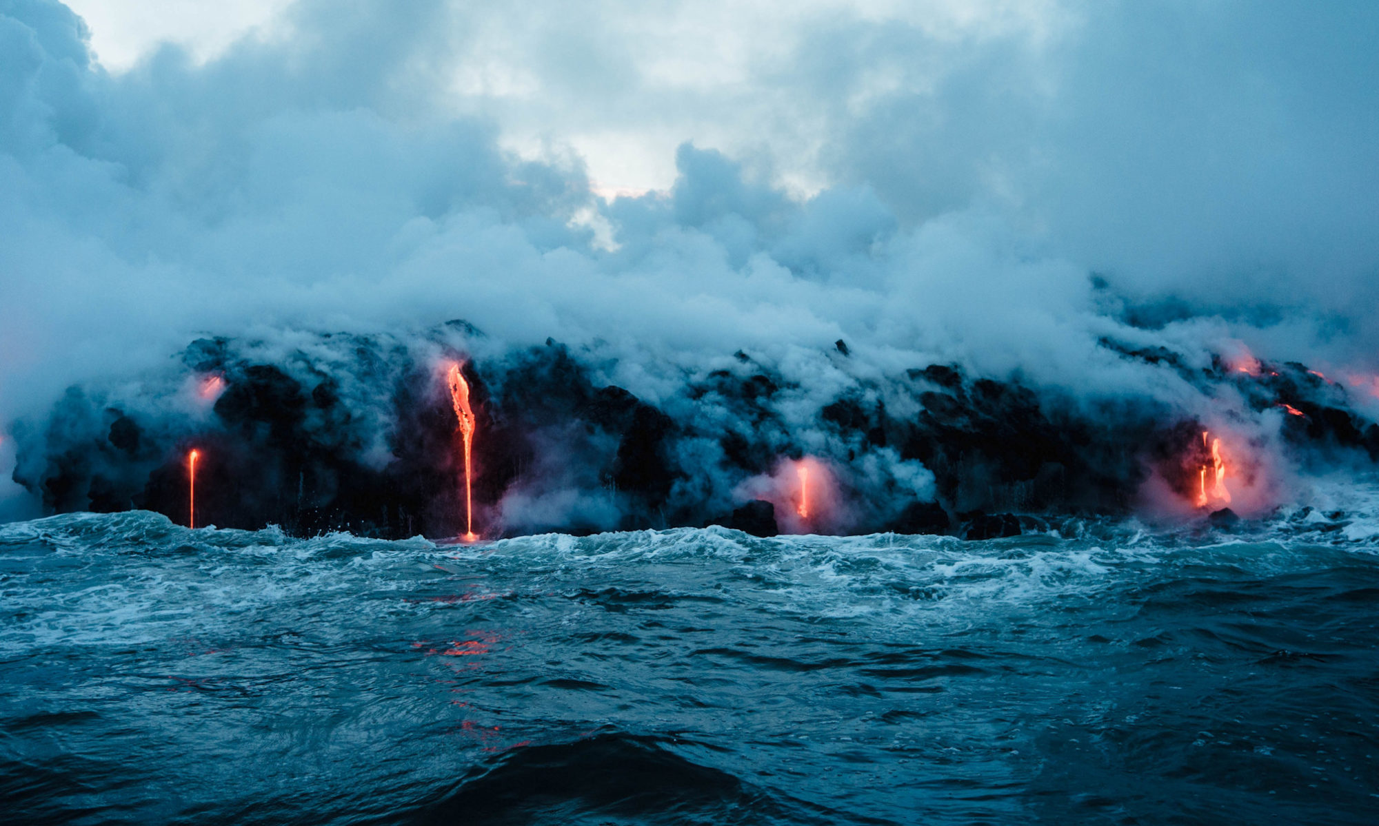
Kilauea (Hawai’i): HVO reported that the eruption on the floor of Kilauea’s Halema’uma’u Crater continued during 15-21 February but at a decreased rate during the last half of the week. Lava erupted from three locations during 15-17 February. The lava lake in E half of the crater was active, had a small lava fountain, and remained at about 10 hectares in size; the smaller western lake in the basin of the 2021-2022 lava lake was also active.
The smaller lava pond in the central portion of the crater floor had a small lava fountain, produced nearly continuous overflows, and channeled lava to the E lake. Activity in the E and central lakes diminished in the late afternoon on 17 February, and by 18 February both had stopped erupting. The western lake was active but at a greatly reduced level and lava only minimally circulated; the lake was mostly crusted over and about 10 m lower by 19 February.
… [read more]
Semisopochnoi (United States, Aleutian Islands): AVO reported that seismicity at Semisopochnoi’s Mount Young was low during 14-21 February, and steam emissions were visible in webcam images almost daily. On 22 February the Aviation Color Code was lowered to Yellow (the second lowest level on a four-color scale) and the Volcano Alert Level was lowered to Advisory (the second highest level on a four-level scale). AVO noted that no significant tremor, ash emissions, or explosive activity had been recorded since late January.
Source: US Geological Survey Alaska Volcano Observatory (AVO)
… [read more]
Great Sitkin (United States, Aleutian Islands): AVO reported that a 15 February satellite image confirmed continuing lava effusion at Great Sitkin and growth of the flow field to the E, though effusion likely continued through 20 February. Weather clouds often obscured satellite and webcam views; steam emissions were observed during 17-18 February and weakly elevated surface temperatures were identified in satellite images during 19-20 February. Seismicity was very low during 21-22 February with one small local earthquake detected.
The Volcano Alert Level remained at Watch (the second highest level on a four-level scale) and the Aviation Color Code remained at Orange (the second highest level on a four-color scale).
… [read more]
Aniakchak (United States, Alaska Peninsula): (23 Feb) The Volcanic Alert Level for the volcano was raised to „yellow“, as an increased number of earthquakes beneath the volcano have been recorded.
The location of earthquakes appears to occur in a SW-NE pattern along the southern and eastern caldera rim. The background seismic activity at the volcano has mostly been characterized by deep (>15 km or 9.3 miles), long-period events that have occurred at a rate of approx. four earthquakes per month. Quakes have become more intense and shallower since October 2022 by now, occurring at less than 9 km depth. The earthquake rate has risen since 31 January with dozens of quakes per day, including M 3.7 event on 17 February.
… [read more]
Trident (United States, Alaska Peninsula): (23 Feb) Seismic activity beneath the volcano has recently increased and is continuing, although no signs of unrest have been detected so far.
Depths of quakes were mostly deep in the beginning, about 25 km, but became rapidly shallower at a depth approx. 5 km beneath the volcano over the following four days. Since early January, earthquakes have become more intense at an average rate of ten per day. The largest event took place on 20 November with a magnitude M 4.6.
… [read more]
Popocatépetl (Central Mexico): Mild explosive activity continues from the volcano. The Volcanic Ash Advisory Center (VAAC) Washington reported intermittent emissions of volcanic ash plumes.
The full report is as follows: sporadic emissions of volcanic ash
…23 Feb:
CENAPRED reported that there were 102-215 steam-and-gas emissions, often containing ash, rising from Popocatépetl each day during 14-21 February; minor explosions also occurred almost daily. Minor explosions were recorded at 1334, 1456, and 1822 on 14 February and at 0253 on 15 February based on data from the seismic network. On 17 February minor explosions occurred at 0210, 1827, 2210, 2252, and 2325.
Additional minor explosions were recorded at 0235, 0252, and 0614 on 18 February; a webcam image from 0236 showed ejected incandescent material on the flanks. The lava dome on the crater floor was visible in satellite images and hadn’t significantly changed since the 27 January overflight. On 20 February a minor explosion was recorded at 1805, and a moderate explosion at 2331 ejected incandescent material onto the upper flanks.
… [read more]
Fuego (Guatemala): Explosive activity continues. Volcanic Ash Advisory Center (VAAC) Washington warned about a volcanic ash plume that rose up to estimated 14000 ft (4300 m) altitude or flight level 140 .
The full report is as follows: VA EMS CONT to 14000 ft (4300 m)
Sangay (Ecuador): Explosive activity continues. Volcanic Ash Advisory Center (VAAC) Washington warned about a volcanic ash plume that rose up to estimated 21000 ft (6400 m) altitude or flight level 210 .
The full report is as follows: VA EMS CONT to 21000 ft (6400 m)
…23 Feb:
IG reported a high level of activity at Sangay during 14-21 February, which included daily explosions, long-period earthquakes, periods of tremor, and gas, steam, and ash emissions. The daily count of explosions ranged from 30-56, though the daily seismic data transmission was sometimes interrupted. Almost daily gas, steam, and ash plumes were either observed in IG webcam images or described in Washington VAAC volcanic activity notifications; weather clouds often prevented observations of the summit.
The plumes rose as high as 1.8 km above the volcano and drifted mainly E, SE, and W. Multiple thermal anomalies were identified in satellite images on most days. Incandescence from the crater, a 500-m-long lava flow on the SE flank, and rolling blocks were visible during the nights of 14-15 and 18-19 February.
… [read more]
Reventador (Ecuador): Explosive activity continues. Volcanic Ash Advisory Center (VAAC) Washington warned about a volcanic ash plume that rose up to estimated 15000 ft (4600 m) altitude or flight level 150 .
The full report is as follows: PSBL VA EMS. to 15000 ft (4600 m)
…23 Feb:
IG described the ongoing eruption at Reventador as moderate during 14-21 February. Seismicity was characterized by explosions, long-period earthquakes, periods of harmonic tremor, and signals that indicated emissions. Steam, gas, and ash plumes were observed in IG webcam images and described in Washington VAAC volcanic activity notifications during 14-19 February; weather conditions occasionally prevented views.
The plumes rose as high as 1.6 km above the summit and drifted in multiple directions. A lava flow on the NE flank was visibly active during 14-15 February. Crater incandescence was visible almost nightly and incandescent blocks were seen rolling as far as 800 m down the flanks in all directions during the beginning of the week.
… [read more]
Cotopaxi (Ecuador): IG reported that the eruption at Cotopaxi continued during 14-21 February, characterized by almost daily emissions of gas, steam, and ash; inclement weather conditions occasionally prevented views. Gas emissions with some ash rose as high as 600 m above the crater rim and drifted E, SE, and SW during 14-15 February. Minor ashfall was noted in San Ramón (17 km SW), Ticatilín (15 km WSW), San Agustín del Callo (18 km WSW), Mulaló (19 km SW), and Lasso (20 km WSW).
Daily ash-and-gas plumes rose as high as 1.1 km during 16-19 February and drifted mainly E, SE, S, and SW. Minor amounts of ash occasionally fell on the downwind flanks. During 20-21 February steam-and-gas plumes rose as high as 1.3 km and drifted E and SW.
… [read more]
Sabancaya (Peru): Explosive activity continues. Volcanic Ash Advisory Center (VAAC) Buenos Aires warned about a volcanic ash plume that rose up to estimated 25000 ft (7600 m) altitude or flight level 250 and is moving at 15 kts in NW direction.
The full report is as follows: PUFF EMISSIONS to 25000 ft (7600 m)
…23 Feb:
Instituto Geofísico del Perú (IGP) reported moderate levels of activity at Sabancaya during 13-19 February with a daily average of 51 explosions. Gas-and-ash plumes rose as high as 2.6 km above the summit and drifted in multiple directions. Four thermal anomalies originating from the lava dome in the summit crater were identified in satellite data.
The Alert Level remained at Orange (the second highest level on a four-color scale) and the public were warned to stay outside of a 12-km radius.
… [read more]
Lascar (Northern Chile): SERNAGEOMIN reported that during 15-21 February seismicity at Láscar continued to be dominated by volcano-tectonic signals with smaller numbers of both long-period and tornillo-type events. Daily whitish gas emissions were mostly diffuse, rose as high as 500 m above the crater rim, and drifted mainly E, SE, and W. Sulfur dioxide emissions were low, no notable deformation was detected, and no thermal anomalies were identified in satellite images.
The Alert Level remained at Orange (the second highest level on a four-color scale) and SENAPRED warned the public to stay at least 10 km away from the crater. ONEMI maintained an Alert Level Yellow (the middle level on a three-color scale) for San Pedro de Atacama (70 km NW).
… [read more]
Villarrica (Central Chile): The eruption at Villarrica was ongoing during 15-21 February. POVI reported that on 17 February Strombolian explosions ejected material 100 m above the crater rim and onto the upper SW flank. Webcam images on 20 February showed two separate fountains of incandescent material, suggesting that a second vent had opened to the E of the first vent.
Spatter was ejected as high as 80 m above the crater rim and onto the upper NE flank. A sequence of Strombolian explosions were visible from 2030 on 20 February to 0630 on 21 February. Material was ejected as high as 80 m above the crater rim and onto the upper E flank.
… [read more]
