Explosive activity continues. Volcanic Ash Advisory Center (VAAC) Darwin warned about a volcanic ash plume that rose up to estimated 7000 ft (2100 m) altitude or flight level 070 . The full report is as follows:
FVAU01 at 12:25 UTC, 14/06/26 from ADRM VA ADVISORY DTG: 20260614/1230Z VAAC: DARWIN VOLCANO: DUKONO 268010 PSN: N0142 E12754 AREA: INDONESIA SOURCE ELEV: 1229M AMSL ADVISORY NR: 2026/374 INFO SOURCE: HIMAWARI-9, CVGHM ERUPTION DETAILS: VA TO FL070 REP AT 14/0737Z MOV NW OBS VA DTG: 14/1210Z OBS VA CLD: SFC/FL070 N0133 E12756 – N0138 E12745 – N0219 E12748 – N0222 E12818 – N0146 E12833 MOV NW 05KT FCST VA CLD +6 HR: 14/1810Z SFC/FL070 N0135 E12743 – N0152 E12741 – N0216 E12819 – N0157 E12842 – N0127 E12834 FCST VA CLD +12 HR: 15/0010Z SFC/FL070 N0153 E12743 – N0156 E12802 – N0127 E12838 – N0104 E12816 – N0116 E12744 FCST VA CLD +18 HR: 15/0610Z SFC/FL070 N0151 E12756 – N0126 E12825 – N0105 E12809 – N0110 E12747 – N0145 E12745 RMK: VA NOT IDENTIFIABLE ON CURRENT SAT IMG DUE TO MET CLOUD. CONTINUING GROUND REPORTS INDICATE EMISSIONS ARE ONGOING. VA HEIGHT AND MOVEMENT BASED ON SATELLITE IMAGERY AND MODEL GUIDANCE. NXT ADVISORY: NO LATER THAN 20260614/1830Z=
Satellite image of Lewotobi volcano on 14 Jun 2026
Explosive activity continues. Volcanic Ash Advisory Center (VAAC) Darwin warned about a volcanic ash plume that rose up to estimated 9000 ft (2700 m) altitude or flight level 090 . The full report is as follows:
FVAU05 at 09:56 UTC, 14/06/26 from ADRM VA ADVISORY DTG: 20260614/1000Z VAAC: DARWIN VOLCANO: LEWOTOBI 264180 PSN: S0833 E12246 AREA: INDONESIA SOURCE ELEV: 1703M AMSL ADVISORY NR: 2026/123 INFO SOURCE: HIMAWARI-9, CVGHM ERUPTION DETAILS: VA TO FL090 OBS AT 14/0940Z MOV NW OBS VA DTG: 14/0940Z OBS VA CLD: SFC/FL090 S0829 E12254 – S0844 E12249 – S0835 E12155 – S0801 E12151 – S0753 E12216 MOV NW 10KT FCST VA CLD +6 HR: 14/1540Z SFC/FL090 S0824 E12256 – S0842 E12257 – S0903 E12217 – S0826 E12155 – S0759 E12223 FCST VA CLD +12 HR: 14/2140Z SFC/FL090 S0836 E12252 – S0906 E12222 – S0845 E12139 – S0802 E12208 – S0824 E12250 FCST VA CLD +18 HR: 15/0340Z SFC/FL090 S0834 E12255 – S0912 E12240 – S0857 E12148 – S0807 E12159 – S0823 E12252 RMK: DISCRETE VA IDENTIFIABLE ON SATELLITE IMAGERY. RECENT CVGHM GROUND REPORTS INDICATE INTERMITTENT VA ERUPTIONS ARE ONGOING. VA HEIGHT AND MOVEMENT BASED ON SATELLITE IMAGERY, GROUND REPORTS AND MODEL GUIDANCE. NXT ADVISORY: NO LATER THAN 20260614/1600Z=
Satellite image of Sabancaya volcano on 14 Jun 2026
Explosive activity continues. Volcanic Ash Advisory Center (VAAC) Buenos Aires warned about a volcanic ash plume that rose up to estimated 27000 ft (8200 m) altitude or flight level 270 and is moving at 20 kts in S direction. The full report is as follows:
FVAG01 at 00:50 UTC, 14/06/26 from SABM VA ADVISORY DTG: 20260614/0100Z
RMK: LATEST WEBCAM OBS SHOWED ISOLATED PUFF EMISSION AT 13/2100Z TL FL270. CURRENTLY ONLY STEAM EMISSION AT SUMMIT. STLT IMAGERY SHOWS REMNANT VA CLD DISSIPATING AND MOV S 20KT …SMN
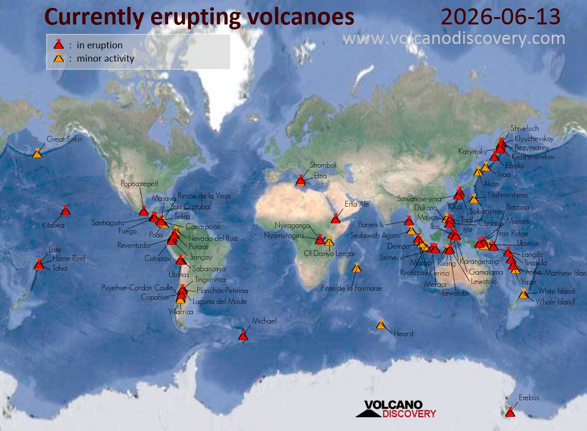
Stromboli (Eolian Islands, Italy): A major explosion occurred yesterday morning that at 05:12 GMT / 07:12 local time, the volcano observatory reported. The explosion occurred in the northern crater area. Lava bombs fell mainly on the upper part of the Sciara del Fuoco. Seismic activity at 05:12 UTC recorded a signal with a higher-than-normal amplitude associated with the major explosion, followed by a phase of moderate increase in amplitude in the first 8 minutes. … [read more] … [show less] The average amplitude of the signal showed a rapid increase, reaching high values during the explosive event, and a subsequent sudden decrease towards medium values, where it remains. No significant changes have been reported in the rate of occurrence of explosive events. Analysis of data from the high-frequency GNSS network shows no significant ground deformation. The overall activity of the volcano (s. att. image) had been set back to medium on 3 June, after it has been at high level for most of May; this is based on a summary of various monitoring data analyzed by volcanologists of the University of Firenze. At the same time, the seismic activity in the southern Tyrrhenian sea has been elevated during the past weeks.
Etna (Sicily, Italy): Near-continuous, but comparably mild ash emissions continue to occur from the Voragine summit crater as our correspondent reports. While no official comment on the activity has been posted (yet) from the volcano observatory, it is obvious that something has changed and the likelihood of more intense activity in the near future has increased. A small swarm of small earthquakes has occurred today under the western flank near Bronte town, with focal depths ranging mostly around 15-10 km depth. Whether this is related to the current activity or whether the quakes indicate magma movements into storage systems below the volcano’s flank at that depth is impossible to determine with certainty from these data alone, but probably, these events are linked in one way or another.
Lewotobi (Flores): Explosive activity continues. Volcanic Ash Advisory Center (VAAC) Darwin warned about a volcanic ash plume that rose up to estimated 9000 ft (2700 m) altitude or flight level 090 . The full report is as follows: VA TO FL090 OBS AT 13/0940Z MOV NW OBS VA DTG:13/0940Z to 9000 ft (2700 m)
Santiaguito (Guatemala): Volcanic Ash Advisory Center Washington (VAAC) issued the following report: ONGOING VA EMISSIONS
Fuego (Guatemala): Volcanic Ash Advisory Center Washington (VAAC) issued the following report: FREQUENT VA EMS
Puracé (Colombia): Volcanic Ash Advisory Center Washington (VAAC) issued the following report: OCNL VA EM LKLY
Reventador (Ecuador): Volcanic Ash Advisory Center Washington (VAAC) issued the following report: OCNL VA EMS
Sabancaya (Peru): Explosive activity continues. Volcanic Ash Advisory Center (VAAC) Buenos Aires warned about a volcanic ash plume that rose up to estimated 27000 ft (8200 m) altitude or flight level 270 and is moving at 10 kts in SE direction. The full report is as follows: VA ERUPTION to 27000 ft (8200 m)