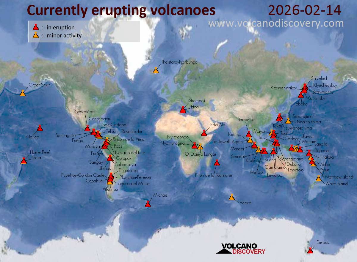
Sakurajima (Kyushu, Japan): The Japan Meteorological Agency (JMA) reported that the eruption continued at Aira between 9 February 2026 (local) and 13 February 2026 (local). A high-sensitivity surveillance camera recorded incandescence at Minamidake Crater at night. The alert level remained at „Level 3 – Restriction on proximity to the volcano“ (on a 5-level scale).
Source: Japan Meteorological Agency (JMA)
… [read more]
Suwanose-jima (Ryukyu Islands): The Japan Meteorological Agency (JMA) reported that the eruption continued at Suwanosejima between 6 February 2026 (local) and 13 February 2026 (local). Gas and vapor plume(s) rose to a maximum of 700 m (2,297 ft) above the vent. The alert level remained at „Level 2 – Restriction on proximity to the crater“ (on a 5-level scale).
Source: Japan Meteorological Agency (JMA)
… [read more]
Canlaon (Central Philippines): The Philippine Institute of Volcanology and Seismology (PHIVOLCS) reported that the eruption continued at Kanlaon on 13 February 2026 (local). A total of 1 ash emission event occurred, lasting 17 minutes. The alert level remained at „2 – Moderate Level of Volcanic Unrest“ (on a 0–5 level scale).
Source: Philippine Institute of Volcanology and Seismology (PHIVOLCS)
… [read more]
Taal (Luzon, Philippines): The Philippine Institute of Volcanology and Seismology (PHIVOLCS) reported that the eruption continued at Taal on 13 February 2026 (local). The alert level remained at „1 – Low-Level Unrest“ (on a 0–5 level scale).
Source: Philippine Institute of Volcanology and Seismology (PHIVOLCS)
… [read more]
Mayon (Luzon Island, Philippines): Volcanic Ash Advisory Center Tokyo (VAAC) issued the following report: ERUPTION AT 20260214/2009Z VA CLD UNKNOWN REPORTED OBS VA DTG:14/2010Z
…14 Feb:
The Philippine Institute of Volcanology and Seismology (PHIVOLCS) reported that the eruption continued at Mayon on 13 February 2026 (local). Lava effusion continued from the summit crater. As of 13 February, lava flow lengths remained at radial distances of 3.8 km in the Basud gully, 1.6 km in the Bonga gully, and 1.3 km in the Mi-isi gully. There were 378 seismically detected rockfalls. Crater glow was visible to the naked eye. Plume(s) rose to a maximum of 250 m (820 ft) above the vent. Sulfur dioxide (SO₂) emissions averaged 3,788 tonnes per day on 13 February. The alert level remained at „3 – Increased Tendency Towards Hazardous Eruption“ (on a 0–5 level scale). Activity also included: seismically detected pyroclastic density current(s) (PDCs).
Source: Philippine Institute of Volcanology and Seismology (PHIVOLCS)
… [read more]
Telong (northern Sumatra, Indonesia): The Center for Volcanology and Geological Hazard/Pusat Vulkanologi dan Mitigasi Bencana Geologi (CVGHM/PVMBG) reported that unrest continued at Telong, Bur ni on 13 February 2026 (local). The alert level remained at „Level 2 – Alert“ (on a 4-level scale).
Source: Center for Volcanology and Geological Hazard/Pusat Vulkanologi dan Mitigasi Bencana Geologi (CVGHM/PVMBG)
… [read more]
Karangetang (Siau Island, Sangihe Islands, Indonesia): The Center for Volcanology and Geological Hazard/Pusat Vulkanologi dan Mitigasi Bencana Geologi (CVGHM/PVMBG) reported that unrest continued at Karangetang on 13 February 2026 (local). The alert level remained at „Level 2 – Alert“ (on a 4-level scale).
Source: Center for Volcanology and Geological Hazard/Pusat Vulkanologi dan Mitigasi Bencana Geologi (CVGHM/PVMBG)
… [read more]
Raung (East Java): The Center for Volcanology and Geological Hazard/Pusat Vulkanologi dan Mitigasi Bencana Geologi (CVGHM/PVMBG) reported that unrest continued at Raung on 13 February 2026 (local). Gas and vapor plume(s) rose to a maximum of 200 m (656 ft) above the vent. The alert level remained at „Level 2 – Alert“ (on a 4-level scale).
Source: Center for Volcanology and Geological Hazard/Pusat Vulkanologi dan Mitigasi Bencana Geologi (CVGHM/PVMBG)
… [read more]
Ibu (Halmahera, Indonesia): Volcanic Ash Advisory Center Darwin (VAAC) issued the following report: VA EMISSION TO FL070 LAST REP FM GND AT 14/1333Z
…14 Feb:
The Center for Volcanology and Geological Hazard/Pusat Vulkanologi dan Mitigasi Bencana Geologi (CVGHM/PVMBG) reported that the eruption continued at Ibu on 13 February 2026 (local). Gas and vapor plume(s) rose to a maximum of 200 m (656 ft) above the vent. There were 124 seismically detected explosions reported. Ash and gas plume(s) rose to a maximum of 600 m (1,969 ft) above the vent. The alert level remained at „Level 2 – Alert“ (on a 4-level scale).
Source: Center for Volcanology and Geological Hazard/Pusat Vulkanologi dan Mitigasi Bencana Geologi (CVGHM/PVMBG)
… [read more]
Tangkubanparahu (West Java): The Center for Volcanology and Geological Hazard/Pusat Vulkanologi dan Mitigasi Bencana Geologi (CVGHM/PVMBG) issued a report for Tangkuban Parahu on 13 February 2026 (local). The alert level remained at „Level 1 – Normal“ (on a 4-level scale).
Source: Center for Volcanology and Geological Hazard/Pusat Vulkanologi dan Mitigasi Bencana Geologi (CVGHM/PVMBG)
… [read more]
Sangeang Api (Flores Sea, Indonesia): The Center for Volcanology and Geological Hazard/Pusat Vulkanologi dan Mitigasi Bencana Geologi (CVGHM/PVMBG) reported that unrest continued at Sangeang Api on 13 February 2026 (local). The alert level remained at „Level 2 – Alert“ (on a 4-level scale).
Source: Center for Volcanology and Geological Hazard/Pusat Vulkanologi dan Mitigasi Bencana Geologi (CVGHM/PVMBG)
… [read more]
Lewotobi (Flores): The Center for Volcanology and Geological Hazard/Pusat Vulkanologi dan Mitigasi Bencana Geologi (CVGHM/PVMBG) reported that unrest continued at Lewotobi (Laki-Laki) on 13 February 2026 (local). The alert level remained at „Level 3 – Standby“ (on a 4-level scale). Activity also included: seismically detected flowage event(s).
Source: Center for Volcanology and Geological Hazard/Pusat Vulkanologi dan Mitigasi Bencana Geologi (CVGHM/PVMBG)
… [read more]
Soputan (North Sulawesi, Indonesia): The Center for Volcanology and Geological Hazard/Pusat Vulkanologi dan Mitigasi Bencana Geologi (CVGHM/PVMBG) reported that unrest continued at Soputan on 13 February 2026 (local). The alert level remained at „Level 2 – Alert“ (on a 4-level scale).
Source: Center for Volcanology and Geological Hazard/Pusat Vulkanologi dan Mitigasi Bencana Geologi (CVGHM/PVMBG)
… [read more]
Lewotolo (Lesser Sunda Islands): The Center for Volcanology and Geological Hazard/Pusat Vulkanologi dan Mitigasi Bencana Geologi (CVGHM/PVMBG) reported that the eruption continued at Lewotolok on 13 February 2026 (local). There were 56 seismically detected explosions reported. The alert level remained at „Level 3 – Standby“ (on a 4-level scale).
Source: Center for Volcanology and Geological Hazard/Pusat Vulkanologi dan Mitigasi Bencana Geologi (CVGHM/PVMBG)
… [read more]
Merapi (Central Java, Indonesia): The Center for Volcanology and Geological Hazard/Pusat Vulkanologi dan Mitigasi Bencana Geologi (CVGHM/PVMBG) reported that the eruption continued at Merapi on 13 February 2026 (local). Gas and vapor plume(s) rose to a maximum of 20 m (66 ft) above the vent. There were 6 hot rockfalls, traveling up to 1,500 m. The alert level remained at „Level 3 – Standby“ (on a 4-level scale).
Source: Center for Volcanology and Geological Hazard/Pusat Vulkanologi dan Mitigasi Bencana Geologi (CVGHM/PVMBG)
… [read more]
Semeru (East Java, Indonesia): Explosive activity continues. Volcanic Ash Advisory Center (VAAC) Darwin warned about a volcanic ash plume that rose up to estimated 18000 ft (5500 m) altitude or flight level 180 .
The full report is as follows: VA TO FL180 REPORTED AT 14/0208Z MOV NE. to 18000 ft (5500 m)
…14 Feb:
The Center for Volcanology and Geological Hazard/Pusat Vulkanologi dan Mitigasi Bencana Geologi (CVGHM/PVMBG) reported that the eruption continued at Semeru on 13 February 2026 (local). There were 58 seismically detected explosions reported. Ash and gas plume(s) were reported. A total of 5 pyroclastic density currents (PDCs), or pyroclastic flows, accompanied eruptions at 1056, 1246, 1422, 1431, and 2002 on 13 February. The PDCs traveled distances ranging from 2,500 m to 4,000 m toward Besuk Kobokan (SE flank), with the longest run-out length recorded at 2002. There were 7 seismically detected rockfalls. The alert level remained at „Level 3 – Standby“ (on a 4-level scale).
Source: Center for Volcanology and Geological Hazard/Pusat Vulkanologi dan Mitigasi Bencana Geologi (CVGHM/PVMBG)
… [read more]
Marapi (Western Sumatra, Indonesia): The Center for Volcanology and Geological Hazard/Pusat Vulkanologi dan Mitigasi Bencana Geologi (CVGHM/PVMBG) reported that the eruption continued at Marapi on 13 February 2026 (local). The alert level remained at „Level 2 – Alert“ (on a 4-level scale).
Source: Center for Volcanology and Geological Hazard/Pusat Vulkanologi dan Mitigasi Bencana Geologi (CVGHM/PVMBG)
… [read more]
Dukono (Halmahera): The Center for Volcanology and Geological Hazard/Pusat Vulkanologi dan Mitigasi Bencana Geologi (CVGHM/PVMBG) reported that the eruption continued at Dukono on 13 February 2026 (local). Gas and vapor plume(s) rose to a maximum of 600 m (1,969 ft) above the vent. The alert level remained at „Level 2 – Alert“ (on a 4-level scale).
Source: Center for Volcanology and Geological Hazard/Pusat Vulkanologi dan Mitigasi Bencana Geologi (CVGHM/PVMBG)
… [read more]
Awu (Sulawesi & Sangihe Islands): The Center for Volcanology and Geological Hazard/Pusat Vulkanologi dan Mitigasi Bencana Geologi (CVGHM/PVMBG) reported that unrest continued at Awu on 13 February 2026 (local). The alert level remained at „Level 2 – Alert“ (on a 4-level scale).
Source: Center for Volcanology and Geological Hazard/Pusat Vulkanologi dan Mitigasi Bencana Geologi (CVGHM/PVMBG)
… [read more]
Kerinci (Sumatra): The Center for Volcanology and Geological Hazard/Pusat Vulkanologi dan Mitigasi Bencana Geologi (CVGHM/PVMBG) reported that unrest continued at Kerinci on 13 February 2026 (local). The alert level remained at „Level 2 – Alert“ (on a 4-level scale).
Source: Center for Volcanology and Geological Hazard/Pusat Vulkanologi dan Mitigasi Bencana Geologi (CVGHM/PVMBG)
… [read more]
Lokon-Empung (North Sulawesi, Indonesia): The Center for Volcanology and Geological Hazard/Pusat Vulkanologi dan Mitigasi Bencana Geologi (CVGHM/PVMBG) reported that unrest continued at Lokon-Empung on 13 February 2026 (local). Gas and vapor plume(s) rose to a maximum of 25 m (82 ft) above the vent. The alert level remained at „Level 2 – Alert“ (on a 4-level scale).
Source: Center for Volcanology and Geological Hazard/Pusat Vulkanologi dan Mitigasi Bencana Geologi (CVGHM/PVMBG)
… [read more]
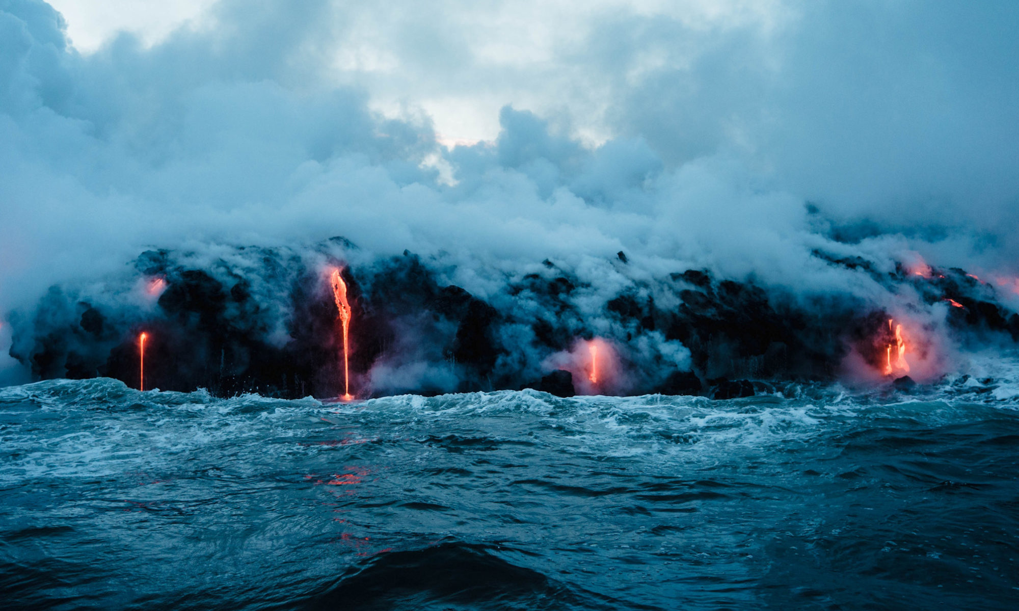
Kilauea (Hawai’i): The United States Geological Survey – Hawaiian Volcano Observatory (USGS-HVO) reported that there was a pause in eruptive activity at Kilauea between 12 February 2026 (local) and 13 February 2026 (local). Moderate glow was observed from the north and south vents overnight in webcam images, with the south vent appearing slightly brighter. Minor lava spattering activity was observed at the south vent briefly before midnight on 12 February. The alert level remained at „Watch“ (level 3 on a 4-level scale). The aviation alert level remained at „Orange“ (level 3 on a 4-level scale).
Source: United States Geological Survey – Hawaiian Volcano Observatory (USGS-HVO)
… [read more]
Late (Tonga, Tonga Islands): Volcanic Ash Advisory Center Wellington (VAAC) issued the following report: ERUPTION AT 20260214/1854Z OBS VA DTG:14/2021Z
Shishaldin (Aleutian Islands, Alaska): The United States Geological Survey – Alaska Volcano Observatory (USGS-AVO) reported that unrest continued at Shishaldin between 12 February 2026 (local) and 13 February 2026 (local). The alert level remained at „Advisory“ (level 2 on a 4-level scale). The aviation alert level remained at „Yellow“ (level 2 on a 4-level scale).
Source: United States Geological Survey – Alaska Volcano Observatory (USGS-AVO)
… [read more]
Great Sitkin (United States, Aleutian Islands): The United States Geological Survey – Alaska Volcano Observatory (USGS-AVO) reported that the eruption continued at Great Sitkin between 12 February 2026 (local) and 13 February 2026 (local). Lava continued to slowly erupt in the summit crater. The alert level remained at „Watch“ (level 3 on a 4-level scale). The aviation alert level remained at „Orange“ (level 3 on a 4-level scale).
Source: United States Geological Survey – Alaska Volcano Observatory (USGS-AVO)
… [read more]
Popocatépetl (Central Mexico): The Centro Nacional de Prevención de Desastres (CENAPRED) reported that the eruption continued at Popocatépetl between 12 February 2026 (local) and 13 February 2026 (local). Gas and vapor plume(s) were reported. The alert level remained at „Yellow Alert – Phase 2“ (level 4 on a 7-level scale).
Source: Centro Nacional de Prevención de Desastres (CENAPRED)
… [read more]
Santiaguito (Guatemala): The Instituto Nacional de Sismología, Vulcanología, Meteorología e Hidrología (INSIVUMEH) reported that the eruption continued at Santa María between 12 February 2026 (local) and 13 February 2026 (local). There were explosions reported, occurring at a rate of up to 2 per hour with plumes rising to a maximum of 3,400 m (11,155 ft) above sea level. There were incandescent rockfalls. Gas and vapor plume(s) rose to a maximum of 400 m (1,312 ft) above the vent.
Source: Instituto Nacional de Sismología, Vulcanología, Meteorología e Hidrología (INSIVUMEH)
… [read more]
Pacaya (Guatemala): The Instituto Nacional de Sismología, Vulcanología, Meteorología e Hidrología (INSIVUMEH) reported that unrest continued at Pacaya between 12 February 2026 (local) and 13 February 2026 (local). Gas and vapor plume(s) were reported.
Source: Instituto Nacional de Sismología, Vulcanología, Meteorología e Hidrología (INSIVUMEH)
… [read more]
Fuego (Guatemala): Explosive activity continues. Volcanic Ash Advisory Center (VAAC) Washington warned about a volcanic ash plume that rose up to estimated 16000 ft (4900 m) altitude or flight level 160 .
The full report is as follows: FRQT LGT VA EMS to 16000 ft (4900 m)
…14 Feb:
The Instituto Nacional de Sismología, Vulcanología, Meteorología e Hidrología (INSIVUMEH) reported that the eruption continued at Fuego between 12 February 2026 (local) and 13 February 2026 (local). There were explosions reported, occurring at a rate of up to 12 per hour, with plumes rising to a maximum of 1,037 m (3,402 ft) above the vent. Fine ash fall was reported in Panimaché Uno, Finca Asunción, La Rochela, Ceylán, and El Zapote. Incandescent material was ejected in pulses above the crater. Gas and vapor plume(s) rose to a maximum of 537 m (1,762 ft) above the vent. Activity also included: audible sounds (e.g., booms, rumbling), shockwave.
Source: Instituto Nacional de Sismología, Vulcanología, Meteorología e Hidrología (INSIVUMEH)
… [read more]
Sangay (Ecuador): Explosive activity continues. Volcanic Ash Advisory Center (VAAC) Washington warned about a volcanic ash plume that rose up to estimated 20000 ft (6100 m) altitude or flight level 200 .
The full report is as follows: ONGOING VA EMS to 20000 ft (6100 m)
…14 Feb:
The Instituto Geofísico-Escuela Politécnica Nacional (IG-EPN) reported that the eruption continued at Sangay between 12 February 2026 (local) and 13 February 2026 (local). There were 150 seismically detected explosions reported. The alert level remained at „2 – Yellow“ (on a 4-level scale).
Source: Instituto Geofísico-Escuela Politécnica Nacional (IG-EPN)
… [read more]
Reventador (Ecuador): The Instituto Geofísico-Escuela Politécnica Nacional (IG-EPN) reported that the eruption continued at Reventador between 12 February 2026 (local) and 13 February 2026 (local). There were 83 seismically detected explosions reported. On the of 12 February, several episodes of crater incandescence were observed. Incandescent blocks were ejected from the crater. There were incandescent rockfalls. A lava flow was observed descending the SE flank. The alert level remained at „3 – Orange“ (on a 4-level scale).
Source: Instituto Geofísico-Escuela Politécnica Nacional (IG-EPN)
… [read more]
Sabancaya (Peru): Explosive activity continues. Volcanic Ash Advisory Center (VAAC) Buenos Aires warned about a volcanic ash plume that rose up to estimated 24000 ft (7300 m) altitude or flight level 240 .
The full report is as follows: VA PUFF to 24000 ft (7300 m)
…14 Feb:
The Centro Vulcanológico Nacional del Instituto Geofísico del Perú (CENVUL-IGP) reported that the eruption continued at Sabancaya between 12 February 2026 (local) and 13 February 2026 (local). Ash, gas, and vapor plume(s) rose to a maximum of 700 m (2,297 ft) above the vent. A total of 11 earthquakes related to the movement of magma and gases were recorded. The alert level remained at „Orange“ (level 3 on a 4-level scale).
Source: Centro Vulcanológico Nacional del Instituto Geofísico del Perú (CENVUL-IGP)
… [read more]
Piton de la Fournaise (La Réunion): The effusive eruption at the volcano continues.
The Volcanological Observatory of Piton de la Fournaise reported that only one eruptive fissure has remained active, located near Piton Morgabim on the south-southeast flank.
The lava flow field has been advancing at a quick pace, currently about 3 km from the RN2 highway.