
Karymsky (Kamchatka): (29 Apr) KVERT reported that a thermal anomaly over Karymsky was visible in satellite images during 15-22 April. Explosions during 17-19 and 21 April generated ash plumes that rose as high as 7.5 km (24,600 ft) a.s.l. and drifted 500 km NE.
SE, and E. A powerful explosion at 0805 on 20 April (local time) generated ash plumes that rose as high as 11 km (36,100 ft) a.s.l. and drifted more than 2,000 km NE.
… [read more]
Shiveluch (Kamchatka): (29 Apr) KVERT reported that a thermal anomaly over Sheveluch was identified in satellite images during 15-22 April, and lava-dome extrusion continued. Explosions during 15-16 April produced ash plumes that rose as high as 5 km (16,400 ft) a.s.l. and drifted about 75 km SE.
The Aviation Color Code remained at Orange (the second highest level on a four-color scale). Dates are based on UTC times; specific events are in local time where noted.
… [read more]
Sakurajima (Kyushu, Japan): (29 Apr) JMA reported that very small eruptive events at Minamidake Crater (at Aira Caldera’s Sakurajima volcano) were recorded during 18-25 April. Crater incandescence was periodically visible at night. The sulfur dioxide emissions were slightly high at 1,300 tons per day on 19 April but then dropped to 500 tons per day on 22 April.
The Alert Level remained at 3 (on a 5-level scale), and residents were warned to stay 2 km away from the crater.
… [read more]
Suwanose-jima (Ryukyu Islands): (29 Apr) JMA reported that eruptive activity continued to be recorded at Suwanosejima’s Ontake Crater during 18-25 April. Eruption plumes rose as high as 1.5 km above the crater rim; no explosions were recorded. The Alert Level remained at 3 and the public was warned to stay 2 km away from the crater.
Source: Japan Meteorological Agency (JMA)
… [read more]
Langila (New Britain, Papua New Guinea): (29 Apr) The Darwin VAAC reported that on 24 April an ash plume from Langila rose 2.1 km (7,000 ft) a.s.l. and drifted SW. The plume had dissipated within 5.5 hours.
Source: Darwin Volcanic Ash Advisory Centre (VAAC)
… [read more]
Ibu (Halmahera, Indonesia): (29 Apr) PVMBG reported that the eruption at Ibu continued during 22-26 April. Daily dense gray ash plumes generally rose 400-1,500 m above the summit and drifted W and NE, though at 0948 on 25 April ash plumes rose up to 3 km above the summit and drifted W. The Alert Level remained at a 2 (on a scale of 1-4), and the public was warned to stay at least 2 km away from the active crater and 3.5 km away on the N side.
Source: Pusat Vulkanologi dan Mitigasi Bencana Geologi (PVMBG, also known as CVGHM)
… [read more]
Lewotolo (Lesser Sunda Islands): Volcanic Ash Advisory Center Darwin (VAAC) issued the following report: VA REPORTED TO FL060 AT 29/0817Z OBS VA DTG:29/1020Z
…29 Apr:
PVMBG reported that the eruption at Lewotolok continued during 19-26 April. Daily white-and-gray ash plumes rose 50-400 m above the summit and drifted W, NW, and E. The Alert Level remained at 3 (on a scale of 1-4) and the public was warned to stay 3 km away from the summit crater and 4 km away from the crater on the SE flank.
Source: Pusat Vulkanologi dan Mitigasi Bencana Geologi (PVMBG, also known as CVGHM)
… [read more]
Krakatau (Sunda Strait, Indonesia): (29 Apr) PVMBG reported that the eruption at Anak Krakatau had intensified. Dense white, gray, and black ash plumes rose as high as 1 km above the summit and drifted SW during 17-19 April. Strombolian activity was first observed on 17 April; that same day that sulfur dioxide emissions increased to 181.1 tons per days from 28.4-68.4 tons per day recorded during 14-15 April.
A dense gray-black ash plume rose around 800 m above the summit at 0621 on 21 April and drifted E. At 0049, 0145, 0237, and 1730 on 22 April dense gray-to-black ash plumes rose 500-1,500 m above the summit and drifted SW. Incandescent material was occasionally ejected above the vent.
… [read more]
…29 Apr:
New aerial and detailed images and videos of the current shape of the volcano have been published today on 28 April.
Given the size of the volcano, it seems to have built a sizeable new cinder cone from the lava-fountaining episode (paroxysm), typically described as „new volcano“.
… [read more]
Sudut lain gambar Gunung Anak Krakatau per tanggal 28 April 2022. Terlihat lobang kawah yang terbuka paska erupsi dan tsunami 2018 sudah tertutup dan pertumbuhan badan gunung sangat signifikan. pic.twitter.com/MyiFffsxBE
— Abdul Muhari (@abdulmuhari) April 28, 2022
Merapi (Central Java, Indonesia): (29 Apr) BPPTKG reported that the eruption at Merapi continued during 15-21 April. The heights and morphologies of the SW lava dome and the central lava dome were unchanged from the previous week, and seismicity remained at high levels. As many as 150 lava avalanches traveled a maximum of 2 km mostly down the Bebeng drainage on the SW flank.
One pyroclastic flows traveled 2 km SW down the Bebeng. The Alert Level remained at 3 (on a scale of 1-4), and the public was warned to stay 3-7 km away from the summit based on location.
… [read more]
Semeru (East Java, Indonesia): (29 Apr) PVMBG reported that the eruption at Semeru continued during 19-26 April. Almost daily ash plumes were visible rising 200-600 m above the summit that drifted N, S, SW, and W. Cloudy weather sometimes prevented visual observations.
The Alert Level remained at 3 (on a scale of 1-4). The public was warned to stay at least 500 m away from Kobokan drainages within 17 km of the summit, along with other drainages originating on Semeru, including the Bang, Kembar, and Sat, due to lahar, avalanche, and pyroclastic flow hazards.
… [read more]
Dukono (Halmahera): (29 Apr) Based on satellite and wind model data, the Darwin VAAC reported that during 21-23 and 25 April ash plumes from Dukono rose to 2.1 km (7,000 ft) a.s.l. and drifted in multiple directions. The Alert Level remained at 2 (on a scale of 1-4), and the public was warned to remain outside of the 2-km exclusion zone.
Sources: Darwin Volcanic Ash Advisory Centre (VAAC),Pusat Vulkanologi dan Mitigasi Bencana Geologi (PVMBG, also known as CVGHM)
… [read more]
Ruapehu (North Island): (29 Apr) On 26 April GeoNet reported that elevated unrest at Ruapehu had been ongoing for the past five weeks, characterized by lake water heating, volcanic gas output, and strong volcanic tremor. Tremor levels fluctuated the past week but represented a record for the longest and strongest tremor episode ever recorded at the volcano. The lake water temperature remained at 37 degrees Celsius, indicating a substantial amount of heat from magma at a shallow depth (0.5-2 km), though water chemistry showed no change based on sampling during 31 March-15 April.
The Volcanic Alert Level remained at 2 (on a scale from 0-5) and the Aviation Color Code remained at Yellow.
… [read more]
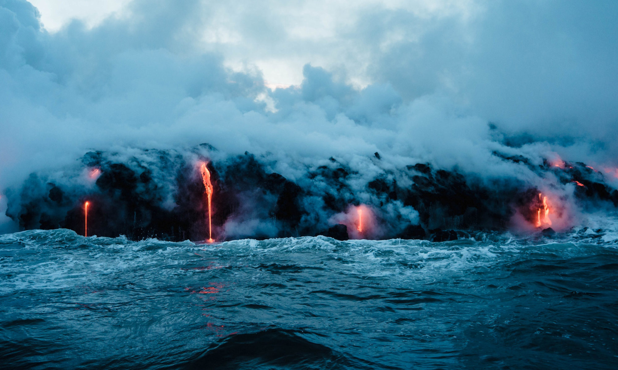
Kilauea (Hawai’i): (29 Apr) HVO reported that lava continued to effuse from a vent in the lower W wall of Kilauea’s Halema`uma`u Crater during 19-26 April, entering an active lava lake and flowing onto the crater floor. The surface of the lava lake was active all week, and the height of the lake fluctuated; the lake occasionally overflowed the rim, sending lava onto the crater floor. Daily breakouts occurred along the N, NE, E, and S parts of the crater.
The Aviation Color Code and the Volcano Alert Level remained at Orange and Watch, respectively.
… [read more]
Wolf (Galápagos Islands, Ecuador): (29 Apr) IG reported that thermal anomalies over Wolf were periodically identified in satellite images during 19-26 April, though were absent on several of the days. Lava advancement was identified in images during 19-21 April; no surface activity was visible the rest of the week.
Source: Instituto Geofísico-Escuela Politécnica Nacional (IG)
… [read more]
Pavlof (Alaska Peninsula, USA): (29 Apr) AVO reported that the eruption at a vent on Pavlof’s upper E flank was ongoing during 20-26 April, though weather conditions sometimes prevented visual observations. Seismic tremor persisted and daily elevated surface temperatures were identified in satellite images. The Volcano Alert Level remained at Watch and the Aviation Color Code remained at Orange.
Source: US Geological Survey Alaska Volcano Observatory (AVO)
… [read more]
Davidof (United States, Aleutian Islands): (29 Apr) AVO lowered both the Aviation Color Code and the Volcano Alert Level for Davidof to Unassigned on 21 April, noting that the earthquake swarm which began in January had declined in the previous few weeks. It is unknown if the swarm was due to tectonic processes or volcanic unrest. The level ?Unassigned? means that there is not sufficient instrumentation on the volcano for AVO to characterize a base level of activity; the closest seismometer was on Little Sitkin (15 km E).
Source: US Geological Survey Alaska Volcano Observatory (AVO)
… [read more]
Semisopochnoi (United States, Aleutian Islands): (29 Apr) AVO reported that low-level eruptive activity at Semisopochnoi’s North Cerberus cone continued during 19-26 April. Periods of seismic tremor were occasionally detected and small explosions were recorded in seismic data during 19-20 April. Minor, low-level, plumes with low ash content were visible in webcam images through each day during 19-20 April, with occasional more energetic ash plumes.
Weather cloud cover often hindered webcam and satellite views during the rest of the week. The Aviation Color Code remained at Orange and the Volcano Alert Level remained at Watch.
… [read more]
Great Sitkin (United States, Aleutian Islands): (29 Apr) AVO reported that slow lava effusion at Great Sitkin continued during 20-26 April, and very low seismicity persisted. The Aviation Color Code and the Volcano Alert Level remained at Orange and Watch, respectively.
Source: US Geological Survey Alaska Volcano Observatory (AVO)
… [read more]
Edgecumbe (United States, Eastern Alaska): (29 Apr) AVO stated that a seismic swarm beneath Kruzof Island near Edgecumbe that began at about 0200 on 11 April had declined to background levels by 22 April. The swarm prompted an in-depth analysis of satellite data which spanned the last 7.5 years. The data showed that a broad area of uplift, about 17 km in diameter, was located about 2.5 km E of Edgecumbe.
The uplift began in August 2018 and deformed at a rate of up to 8.7 cm per year in the center of the area, totaling 27 cm of uplift; the deformation was ongoing. Retrospective analysis of seismic data revealed that earthquakes started occurring in 2020, though the recent swarm was unusual. The deformation and seismic data together suggested magma movement beneath the volcano, consistent with an intrusion at about 5 km below sea level.
… [read more]
Popocatépetl (Central Mexico): (29 Apr) CENAPRED reported that the eruption at Popocatépetl continued during 19-26 April. Each day there were 6-27 steam-and-gas emissions that rose from the crater and drifted mainly SW. The plumes sometimes contained ash.
Incandescence from the crater was sometimes visible at night. Two minor explosions were recorded at 0152 and 0559 on 21 April. The Alert Level remained at Yellow, Phase Two (the middle level on a three-color scale).
… [read more]
Santiaguito (Guatemala): (29 Apr) INSIVUMEH reported that the eruption at Santa María’s Santiaguito lava-dome complex continued during 21-25 April. Incandescence from Caliente crater and the lava flows on the W and SW flanks was visible nightly and early mornings. Avalanches of blocks descended the W and SW flanks of Caliente.
The lava flows continued to advance, traveling as far as 2.5 km in the San Isidro channel, and produced block avalanches from the ends and sides of the flows that descended the S, SW, and S flanks. Ash from these avalanches fell in areas around the volcano and a sulfur odor was also occasionally noticed.
… [read more]
Fuego (Guatemala): (29 Apr) INSIVUMEH reported that 2-10 explosions per hour were recorded at Fuego during 21-25 April, generating ash plumes that rose as high as 1.3 km above the crater rim. The ash plumes mainly drifted as far as 15 km SE, S, and SW causing daily ashfall in areas downwind including Morelia (9 km SW), Panimaché I and II (8 km SW), Santa Sofía (12 km SW), El Porvenir (8 km ENE), Sangre de Cristo (8 km WSW), Finca Palo Verde, Finca la Asunción, El Zapote (10 km S), San Pedro Yepocapa (8 km NW), Ceylon, San Andrés Osuna, and La Rochela. Shock waves rattled structures in communities around the volcano on most days and occasional rumbling was heard.
Block avalanches descended the flanks in all directions, but most commonly were visible in the Ceniza (SSW), Seca (W), Trinidad (S), Taniluyá (SW), Honda, and Las Lajas (SE) drainages, often reaching vegetated areas. Explosions ejected incandescent material 100-350 m above the summit during 21-24 April.
… [read more]
Rincón de la Vieja (Costa Rica): (29 Apr) OVSICORI-UNA reported that a small eruptive event at Rincón de la Vieja was recorded at 0618 on 25 April, though it was not visible due to weather conditions. Another small event was recorded at 0156 on 26 April; the plume was not visible due to conditions.
Source: Observatorio Vulcanologico y Sismologico de Costa Rica-Universidad Nacional (OVSICORI-UNA)
… [read more]
Nevado del Ruiz (Colombia): Explosive activity continues. Volcanic Ash Advisory Center (VAAC) Washington warned about a volcanic ash plume that rose up to estimated 20000 ft (6100 m) altitude or flight level 200 .
The full report is as follows: VA EMS LIKELY NW OF SUMMIT to 20000 ft (6100 m)
Puracé (Colombia): (29 Apr) Observatorio Vulcanológico y Sismológico de Popayán, Servicio Geologico Colombiano (SGC), reported that during 19-25 April the number and magnitudes of earthquakes at Puracé was similar to the previous week. Signals included 72 volcano-tectonic (VT) events, indicating rock fracturing, along with 207 long-period (LP) events and 14 low-energy tremor pulses, indicating fluid movement. Data from the GNSS (Global Navigation Satellite System) geodetic network continued to show inflation on the centimeter scale.
Sulfur dioxide emissions were lower than the previous week, with values of 937-992 tonnes per day, and gas plumes drifted NW. During a field visit on 22 April scientists observed no changes to the crack near Puracé and Curiquinga volcanoes, and no visible gas emissions. Additional cracks, oriented NW-SE, were observed, in addition to volcanic ash deposits that were likely emplaced on 29 March.
… [read more]
Sangay (Ecuador): Explosive activity continues. Volcanic Ash Advisory Center (VAAC) Washington warned about a volcanic ash plume that rose up to estimated 23000 ft (7000 m) altitude or flight level 230 .
The full report is as follows: NEW VA EMS OBS IN STLT to 23000 ft (7000 m)
Reventador (Ecuador): (29 Apr) Explosive activity continues. Volcanic Ash Advisory Center (VAAC) Washington warned about a volcanic ash plume that rose up to estimated 15000 ft (4600 m) altitude or flight level 150 .
The full report is as follows: VA EMS POSS to 15000 ft (4600 m)
Sabancaya (Peru): Explosive activity continues. Volcanic Ash Advisory Center (VAAC) Buenos Aires warned about a volcanic ash plume that rose up to estimated 24000 ft (7300 m) altitude or flight level 240 and is moving at 15 kts in SW direction.
The full report is as follows: continuous ash emissions to 24000 ft (7300 m)
…29 Apr:
Instituto Geofísico del Perú (IGP) reported moderate levels of activity at Sabancaya during 18-24 April with a daily average of 37 explosions. Gas-and-ash plumes rose as high as 2.3 km above the summit and drifted N, NE, SE, and S. As many as 10 thermal anomalies originating from the lava dome in the summit crater were identified in satellite data.
Minor inflation continued to be detected near Hualca Hualca (4 km N). The Alert Level remained at Orange (the second highest level on a four-color scale) and the public were warned to stay outside of a 12-km radius.
… [read more]
Volcano Activity Summary for 29 Apr 2022:
