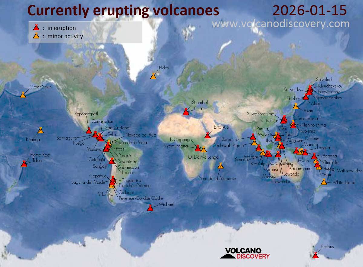
Indonesia led today’s global volcano picture with numerous ongoing eruptions, plus one notable uptick and a slowdown in the Andes. Activity increased at Lewotolok, while Sangay in Ecuador eased; steady eruptions also held at Popocatepetl, Reventador, and Sabancaya.
Indonesia Activity was widespread. Lewotolok showed increased eruptive activity while holding at Level 2. Higher alert conditions persisted at Merapi, Semeru, and Lewotobi (all Level 3). Eruptions continued at Dukono, Ibu, and Marapi, and Kerinci stayed in unrest at Level 2.
Mexico Popocatepetl remained in eruption at Yellow Alert – Phase 2.
South America Colombia’s Purace and Peru’s Sabancaya kept their Orange-level eruptions, alongside Ecuador’s Reventador. Meanwhile, Ecuador’s Sangay showed decreased activity at Yellow.
Ibu (Halmahera, Indonesia): The Center for Volcanology and Geological Hazard/Pusat Vulkanologi dan Mitigasi Bencana Geologi (CVGHM/PVMBG) reported that the eruption continued at Ibu on 14 January 2026 (local). The alert level remained at „Level 2 – Alert“ (on a 4-level scale). Source: Center for Volcanology and Geological Hazard/Pusat Vulkanologi dan Mitigasi Bencana Geologi (CVGHM/PVMBG) … [read more] … [show less] Current Alerts: Observatory alert level: „Level 2 – Alert“ (on a 4-level scale)
Lewotobi (Flores): The Center for Volcanology and Geological Hazard/Pusat Vulkanologi dan Mitigasi Bencana Geologi (CVGHM/PVMBG) reported that the eruption continued at Lewotobi (Laki-Laki) on 14 January 2026 (local). The alert level remained at „Level 3 – Standby“ (on a 4-level scale). Source: Center for Volcanology and Geological Hazard/Pusat Vulkanologi dan Mitigasi Bencana Geologi (CVGHM/PVMBG) … [read more] … [show less] Current Alerts: Observatory alert level: „Level 3 – Standby“ (on a 4-level scale)
Lewotolo (Lesser Sunda Islands): The Center for Volcanology and Geological Hazard/Pusat Vulkanologi dan Mitigasi Bencana Geologi (CVGHM/PVMBG) reported that eruptive activity increased at Lewotolok on 14 January 2026 (local). The alert level remained at „Level 2 – Alert“ (on a 4-level scale). Source: Center for Volcanology and Geological Hazard/Pusat Vulkanologi dan Mitigasi Bencana Geologi (CVGHM/PVMBG) … [read more] … [show less] Current Alerts: Observatory alert level: „Level 2 – Alert“ (on a 4-level scale)
Merapi (Central Java, Indonesia): The Center for Volcanology and Geological Hazard/Pusat Vulkanologi dan Mitigasi Bencana Geologi (CVGHM/PVMBG) reported that the eruption continued at Merapi on 14 January 2026 (local). The alert level remained at „Level 3 – Standby“ (on a 4-level scale). Source: Center for Volcanology and Geological Hazard/Pusat Vulkanologi dan Mitigasi Bencana Geologi (CVGHM/PVMBG) … [read more] … [show less] Current Alerts: Observatory alert level: „Level 3 – Standby“ (on a 4-level scale)
Semeru (East Java, Indonesia): The Center for Volcanology and Geological Hazard/Pusat Vulkanologi dan Mitigasi Bencana Geologi (CVGHM/PVMBG) reported that the eruption continued at Semeru on 14 January 2026 (local). The alert level remained at „Level 3 – Standby“ (on a 4-level scale). Source: Center for Volcanology and Geological Hazard/Pusat Vulkanologi dan Mitigasi Bencana Geologi (CVGHM/PVMBG) … [read more] … [show less] Current Alerts: Observatory alert level: „Level 3 – Standby“ (on a 4-level scale)
Marapi (Western Sumatra, Indonesia): The Center for Volcanology and Geological Hazard/Pusat Vulkanologi dan Mitigasi Bencana Geologi (CVGHM/PVMBG) reported that the eruption continued at Marapi on 14 January 2026 (local). The alert level remained at „Level 2 – Alert“ (on a 4-level scale). Source: Center for Volcanology and Geological Hazard/Pusat Vulkanologi dan Mitigasi Bencana Geologi (CVGHM/PVMBG) … [read more] … [show less] Current Alerts: Observatory alert level: „Level 2 – Alert“ (on a 4-level scale)
Dukono (Halmahera): The Center for Volcanology and Geological Hazard/Pusat Vulkanologi dan Mitigasi Bencana Geologi (CVGHM/PVMBG) reported that the eruption continued at Dukono on 14 January 2026 (local). The alert level remained at „Level 2 – Alert“ (on a 4-level scale). Source: Center for Volcanology and Geological Hazard/Pusat Vulkanologi dan Mitigasi Bencana Geologi (CVGHM/PVMBG) … [read more] … [show less] Current Alerts: Observatory alert level: „Level 2 – Alert“ (on a 4-level scale)
Kerinci (Sumatra): The Center for Volcanology and Geological Hazard/Pusat Vulkanologi dan Mitigasi Bencana Geologi (CVGHM/PVMBG) reported that unrest continued at Kerinci on 14 January 2026 (local). The alert level remained at „Level 2 – Alert“ (on a 4-level scale). Source: Center for Volcanology and Geological Hazard/Pusat Vulkanologi dan Mitigasi Bencana Geologi (CVGHM/PVMBG) … [read more] … [show less] Current Alerts: Observatory alert level: „Level 2 – Alert“ (on a 4-level scale)
Kilauea (Hawai’i): The Hawaiian Volcano Observatory (HVO) detected an earthquake swarm beneath the summit of Kilauea volcano, which could (but not necessarily must) herald a possible change in eruption style: „On Wednesday, January 14 at 7:35 p.m. HST, a swarm of earthquakes began beneath Halemaʻumaʻu crater at the summit of Kīlauea. Elevated seismic activity gradually died down in frequency of occurrence and intensity, over the course of 40 minutes. Locations of these earthquakes are spread broadly beneath east side of Halemaʻumaʻu crater and the south caldera. All of the detected earthquakes have been less than magnitude-2, with most being magnitude-1 or smaller. … [read more] … [show less] This is the third small swarm of earthquakes beneath Halemaʻumaʻu crater since the end of episode 40. The first swarm began at 12:40 a.m. HST and lasted for 30 minutes on Tuesday, January 13. It was followed the next day by a second swarm around 9:10 a.m. HST, and lasted less than 30 minutes on Wednesday morning, January 14. The first and second swarms both had magnitude ranges similar to the third. Most of the earthquakes seem to be occurring around the shallow Halemaʻumaʻu magma chamber, some 1.5 to 4 km beneath the surface. Most of the earthquakes are volcano-tectonic earthquakes that accompany crack opening due to magmatic pressure. Elevated seismic activity of these intensities have not been seen at the summit since the start of the eruption in December 2024. A small swarm did precede a new fissure opening in the wall of the Halemaʻumaʻu crater just to the south of the vents, at the start of episode 30. It is yet to be determined if these swarms after episode 40 will have an impact on lava-fountaining activity at the surface.
Pavlof (Alaska Peninsula, USA): Increased seismic activity has been detected at the volcano and its alert status was raised to Yellow. The Alaska Volcano Observatory reports: „The rate of long-period earthquakes has increased at Pavlof Volcano since approximately 12:45 am AKST (09:45 UTC) on January 14. No eruptive activity or emissions from the summit have been observed including in clear webcam images from this morning. The earthquake activity represents an increase from background levels, therefore the Alaska Volcano Observatory is raising the Aviation Color Code and Alert Level to YELLOW/ADVISORY. This type of earthquake activity in the past has preceded eruptions, but also has ended without an eruption occurring. We will continue to closely monitor the volcano for signs of increased activity, as eruptions at Pavlof Volcano often occur suddenly with little or no warning. The last eruption at Pavlof Volcano occurred in 2021 and 2022, and consisted of small lava flows and low-level explosions primarily from a vent on the upper southeast flank. Larger ash-producing eruptions last occurred at Pavlof in 2013, 2014, and 2016 from a crater on the upper north flank.“
Popocatépetl (Central Mexico): The Centro Nacional de Prevención de Desastres (CENAPRED) reported that the eruption continued at Popocatépetl between 13 January 2026 (local) and 14 January 2026 (local). The alert level remained at „Yellow Alert – Phase 2“ (level 4 on a 7-level scale). Source: Centro Nacional de Prevención de Desastres (CENAPRED) … [read more] … [show less] Current Alerts: Observatory alert level: „Yellow Alert – Phase 2“ (level 4 on a 7-level scale)
Santiaguito (Guatemala): (15 Jan) Volcanic Ash Advisory Center Washington (VAAC) issued the following report: OCNL VA EMS
Fuego (Guatemala): Explosive activity continues. Volcanic Ash Advisory Center (VAAC) Washington warned about a volcanic ash plume that rose up to estimated 14000 ft (4300 m) altitude or flight level 140 . The full report is as follows: ONGOING VA EMS to 14000 ft (4300 m)
Puracé (Colombia): The Servicio Geológico Colombiano (SGC) reported that the eruption continued at Puracé between 13 January 2026 (local) and 14 January 2026 (local). The alert level remained at „Orange“ (level 3 on a 4-level scale). Source: Servicio Geológico Colombiano (SGC) … [read more] … [show less] Current Alerts: Observatory alert level: „Orange“ (level 3 on a 4-level scale)
Sangay (Ecuador): Explosive activity continues. Volcanic Ash Advisory Center (VAAC) Washington warned about a volcanic ash plume that rose up to estimated 20000 ft (6100 m) altitude or flight level 200 . The full report is as follows: POSS VA EMS to 20000 ft (6100 m) …15 Jan: The Instituto Geofísico-Escuela Politécnica Nacional (IG-EPN) reported that eruptive activity decreased at Sangay between 13 January 2026 (local) and 14 January 2026 (local). The alert level remained at „2 – Yellow“ (on a 4-level scale). Source: Instituto Geofísico-Escuela Politécnica Nacional (IG-EPN) … [read more] … [show less] Current Alerts: Observatory alert level: „2 – Yellow“ (on a 4-level scale)
Reventador (Ecuador): The Instituto Geofísico-Escuela Politécnica Nacional (IG-EPN) reported that the eruption continued at Reventador between 13 January 2026 (local) and 14 January 2026 (local). The alert level remained at „3 – Orange“ (on a 4-level scale). Source: Instituto Geofísico-Escuela Politécnica Nacional (IG-EPN) … [read more] … [show less] Current Alerts: Observatory alert level: „3 – Orange“ (on a 4-level scale)
Sabancaya (Peru): The Centro Vulcanológico Nacional del Instituto Geofísico del Perú (CENVUL-IGP) reported that the eruption continued at Sabancaya between 13 January 2026 (local) and 14 January 2026 (local). The alert level remained at „Orange“ (level 3 on a 4-level scale). Source: Centro Vulcanológico Nacional del Instituto Geofísico del Perú (CENVUL-IGP) … [read more] … [show less] Current Alerts: Observatory alert level: „Orange“ (level 3 on a 4-level scale)
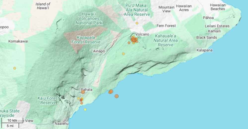
Location of quakes under Kilauea volcano during the past 24 hours
The Hawaiian Volcano Observatory (HVO) detected an earthquake swarm beneath the summit of Kilauea volcano, which could (but not necessarily must) herald a possible change in eruption style: „On Wednesday, January 14 at 7:35 p.m. HST, a swarm of earthquakes began beneath Halemaʻumaʻu crater at the summit of Kīlauea. Elevated seismic activity gradually died down in frequency of occurrence and intensity, over the course of 40 minutes. Locations of these earthquakes are spread broadly beneath east side of Halemaʻumaʻu crater and the south caldera. All of the detected earthquakes have been less than magnitude-2, with most being magnitude-1 or smaller.
This is the third small swarm of earthquakes beneath Halemaʻumaʻu crater since the end of episode 40. The first swarm began at 12:40 a.m. HST and lasted for 30 minutes on Tuesday, January 13. It was followed the next day by a second swarm around 9:10 a.m. HST, and lasted less than 30 minutes on Wednesday morning, January 14. The first and second swarms both had magnitude ranges similar to the third. Most of the earthquakes seem to be occurring around the shallow Halemaʻumaʻu magma chamber, some 1.5 to 4 km beneath the surface.
Most of the earthquakes are volcano-tectonic earthquakes that accompany crack opening due to magmatic pressure. Elevated seismic activity of these intensities have not been seen at the summit since the start of the eruption in December 2024. A small swarm did precede a new fissure opening in the wall of the Halemaʻumaʻu crater just to the south of the vents, at the start of episode 30. It is yet to be determined if these swarms after episode 40 will have an impact on lava-fountaining activity at the surface.
Volcanic systems remain a complex balance of magmatic pressure and strength of the surrounding rocks. If the rocks weaken, one possible outcome is injection of a magma into a fracture creating a dike. If the magma breaches the surface a new vent might be created shifting the focus of the eruption. Historically, episodic fountain eruptions can cease when the magma supply is diverted in this manner.
Currently all of the activity remains beneath Kīlauea caldera and there is no observable evidence that magma is migrating away from this area. Both the east and the southwest rift zones remain quiet at this time.“
Indonesia dominated today’s activity, with multiple eruptions holding at mid-level alerts and a notable uptick at Lewotolok. Activity at Ecuador’s Sangay decreased, while Popocatepetl and several Andean volcanoes stayed in eruption.
Indonesia Eruptive output increased at Lewotolok (Level 2 – Alert). Ongoing eruptions persisted at Merapi, Semeru, and Lewotobi (all Level 3 – Standby). Marapi, Ibu, and Dukono held at Level 2 – Alert, while Kerinci showed ongoing unrest at Level 2.
Mexico Popocatepetl continued its long-running eruption (Yellow Alert – Phase 2).
South America Colombia’s Purace and Peru’s Sabancaya remained eruptive (both Orange). In Ecuador, Reventador stayed at Orange while Sangay decreased (Yellow).
Volcanic Ash Advisory Center Tokyo (VAAC) issued the following report:
FVFE01 at 06:28 UTC, 15/01/26 from RJTD VA ADVISORY DTG: 20260115/0628Z VAAC: TOKYO VOLCANO: KANLAON 272020 PSN: N1025 E12308 AREA: PHILIPPINES SOURCE ELEV: 2435M AMSL ADVISORY NR: 2026/19 INFO SOURCE: HIMAWARI-9 PHIVOLCS ERUPTION DETAILS: ERUPTION AT 20260115/0612Z FL090 EXTD SE REPORTED OBS VA DTG: 15/0610Z OBS VA CLD: VA NOT IDENTIFIABLE FM SATELLITE DATA WIND FL090 010/22KT
FCST VA CLD +6 HR: NOT AVBL FCST VA CLD +12 HR: NOT AVBL FCST VA CLD +18 HR: NOT AVBL RMK: WE WILL ISSUE FURTHER ADVISORY IF VA IS DETECTED IN SATELLITE IMAGERY. NXT ADVISORY: NO FURTHER ADVISORIES=