
From 23/01/2026 to 23/01/2026, a Tropical Storm (maximum wind speed of 102 km/h) LUANA-26 was active in SEIndian. The cyclone affects these countries: Australia (vulnerability Low). Estimated population affected by category 1 (120 km/h) wind speeds or higher is 0 (1276 in tropical storm).
Semeru Volcano Volcanic Ash Advisory: ERUPTION LAST REPORTED AT 23/0000Z EST VA DTG: 23/0250Z
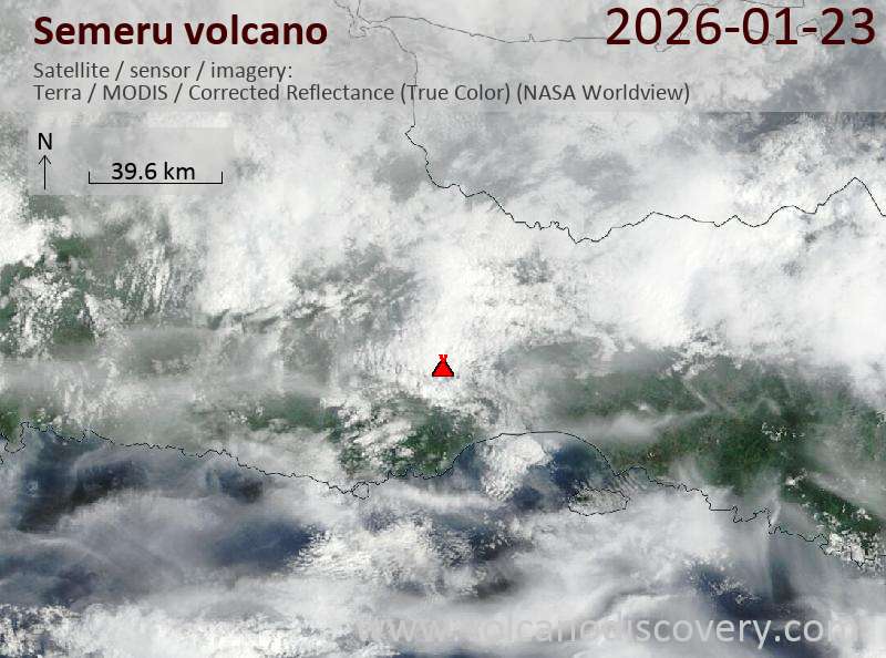
Satellite image of Semeru volcano on 23 Jan 2026
Volcanic Ash Advisory Center Darwin (VAAC) issued the following report:
FVAU02 at 03:04 UTC, 23/01/26 from ADRM
VA ADVISORY
DTG: 20260123/0310Z
VAAC: DARWIN
VOLCANO: SEMERU 263300
PSN: S0806 E11255
AREA: INDONESIA
SOURCE ELEV: 3657M AMSL
ADVISORY NR: 2026/91
INFO SOURCE: CVGHM, HIMAWARI-9
ERUPTION DETAILS: ERUPTION LAST REPORTED AT 23/0000Z
EST VA DTG: 23/0250Z
EST VA CLD: SFC/FL150 S0803 E11254 – S0808 E11331 – S0824
E11326 – S0807 E11252 MOV E 30KT
FCST VA CLD +6 HR: 23/0850Z SFC/FL150 S0807 E11252 – S0803
E11254 – S0813 E11331 – S0827 E11322
FCST VA CLD +12 HR: 23/1450Z SFC/FL150 S0803 E11254 – S0813
E11331 – S0827 E11322 – S0807 E11252 – S0807 E11252
FCST VA CLD +18 HR: 23/2050Z SFC/FL150 S0807 E11252 – S0803
E11254 – S0813 E11330 – S0827 E11322
RMK: VA NOT IDENTIFIABLE ON CURRENT SATELLITE IMAGERY DUE TO
MET CLOUD, HOWEVER GROUND REPORTS INDICATE INTERMITTENT
DISCRETE ERUPTIONS COULD BE ONGOING. VA HEIGHT AND MOVEMENT
BASED ON RECENT GROUND REPORTS AND MODEL GUIDANCE.
NXT ADVISORY: NO LATER THAN 20260123/0910Z=
Sangay surges with lava and ash as Semeru alert drops and Poas turns Yellow
Explosive Andean and Indonesian volcanoes stood out today, led by Sangay and Fuego, while Mayon’s effusion persisted in the Philippines. Notable shifts from yesterday include Semeru’s alert lowered to Level 2, Poas now Aviation Yellow, Piton de la Fournaise listed as a continuing eruption, and ash reported at Sangay and Purace.
Indonesia
Lewotolok produced 648 seismically detected explosions. Semeru recorded 121 explosions and four rockfalls (Level 2 – Alert). Ibu registered 124 explosions with low gas plumes, while Merapi sent two hot rockfalls up to 1.8 km. Low plumes persisted at Dukono and activity at Marapi stayed modest; several other Indonesian volcanoes remained in unrest, and Tangkuban Parahu held at Level 1 – Normal.
Philippines
Mayon displayed lava effusion and dome growth with minor Strombolian bursts; 317 rockfalls and seismically detected pyroclastic density currents were noted (Alert Level 3). Kanlaon emitted plumes to 300 m. Taal produced plumes to 450 m and experienced a continuous tremor episode beginning at 0900 (Alert Level 1).
Mexico
Popocatepetl continued with gas-and-steam emissions (Yellow Alert – Phase 2).
South America
In Ecuador, Sangay generated 374 explosions, ash-and-gas plumes to 1.5 km, and a small SE-flank lava flow confined near the crater, while Reventador produced 94 explosions with ash to 1 km and thermal anomalies. Peru’s Sabancaya sent ash-and-gas plumes to 1 km alongside a dozen internal earthquakes, and Colombia’s Purace produced a single ash emission to 300 m amid ongoing tremor and degassing.
Africa
Piton de la Fournaise was classified as a continuing eruption (Alert 2-1).
Other
Guatemala’s Fuego was very active with up to 10 explosions per hour, plumes rising as high as 4.7 km above the vent, and incandescent ejecta causing rockfalls and audible booms. Santa Maria produced up to two explosions per hour, plumes to 800 m, and nighttime crater incandescence with rockfalls. In Costa Rica, Poas remained at Level 2 – Warning and is now Aviation Yellow, while Rincon de la Vieja and Turrialba stayed at Level 2 – Warning.
Source: Smithsonian/USGS GVP Daily Volcanic Activity Report (21 January 2026).
Activity Summary for 21 January 2026
| Volcano | Country | Activity Type | Keynotes |
|---|---|---|---|
| Dukono | Indonesia | Eruption | Gas-and-steam plumes to 250 m. |
| Fuego | Guatemala | Eruption | Up to 10 explosions/hr; plumes to 4.7 km; incandescent ejecta with rockfalls. |
| Ibu | Indonesia | Eruption | 124 explosions; gas plumes to 200 m; felt seismicity. |
| Kanlaon | Philippines | Eruption | Plumes to 300 m. |
| Lewotolok | Indonesia | Eruption | 648 explosions detected; eruption ongoing. |
| Marapi | Indonesia | Eruption | Eruption ongoing; Alert Level 2 – Alert. |
| Mayon | Philippines | Eruption | Lava effusion with dome growth; minor Strombolian activity; 317 rockfalls and seismically detected PDCs. |
| Merapi | Indonesia | Eruption | 2 hot rockfalls to 1.8 km. |
| Piton de la Fournaise | France | Eruption | Eruption ongoing; Alert 2-1. |
| Popocatepetl | Mexico | Eruption | Gas-and-steam emissions. |
| Poas | Costa Rica | Eruption | Eruption ongoing; Level 2 – Warning; Aviation Yellow. |
| Purace | Colombia | Eruption | Single ash emission to 300 m; tremor pulses and LP events; sustained degassing. |
| Reventador | Ecuador | Eruption | 94 explosions; ash-and-gas plumes to 1 km; thermal anomaly. |
| Sabancaya | Peru | Eruption | Ash-and-gas plumes to 1 km; 12 internal earthquakes; thermal anomalies. |
| Sangay | Ecuador | Eruption | 374 explosions; ash-and-gas plumes to 1.5 km; small SE-flank lava flow. |
| Santa Maria | Guatemala | Eruption | Up to 2 explosions/hr; plumes to 800 m; nighttime incandescence with rockfalls. |
| Semeru | Indonesia | Eruption | 121 explosions; 4 rockfalls. |
| Taal | Philippines | Eruption | Plumes to 450 m; continuous tremor episode from 0900. |
| Awu | Indonesia | Unrest | Ongoing unrest; Alert Level 2 – Alert. |
| Bur ni Telong | Indonesia | Unrest | Ongoing unrest; Alert Level 2 – Alert. |
| Iliwerung | Indonesia | Unrest | Ongoing unrest; Alert Level 2 – Alert. |
| Karangetang | Indonesia | Unrest | Ongoing unrest; Alert Level 2 – Alert. |
| Kerinci | Indonesia | Unrest | Felt seismicity; ongoing unrest. |
| Lewotobi | Indonesia | Unrest | Ongoing unrest; Alert Level 3 – Standby. |
| Lokon-Empung | Indonesia | Unrest | Ongoing unrest; Alert Level 2 – Alert. |
| Raung | Indonesia | Unrest | Ongoing unrest; Alert Level 2 – Alert. |
| Rincon de la Vieja | Costa Rica | Unrest | Ongoing unrest; Level 2 – Warning. |
| Sangeang Api | Indonesia | Unrest | Ongoing unrest; Alert Level 2 – Alert. |
| Soputan | Indonesia | Unrest | Ongoing unrest; Alert Level 2 – Alert. |
| Turrialba | Costa Rica | Unrest | Ongoing unrest; Level 2 – Warning. |
| Tangkuban Parahu | Indonesia | Background | Background state; Level 1 – Normal. |
Volcanic activity worldwide 22 Jan 2026: Santiaguito volcano, Fuego, Popocatépetl, Soputan, Tangkub…
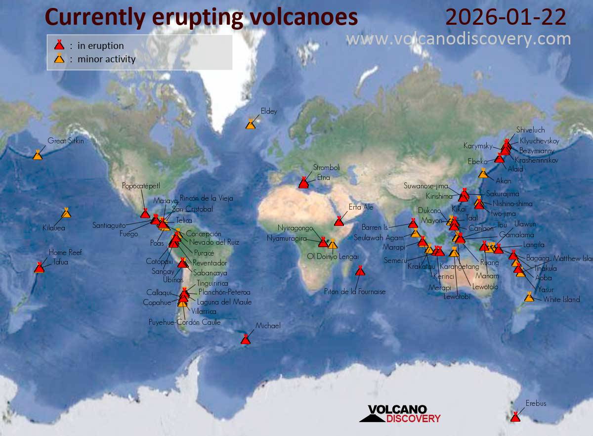
Map of today’s active volcanoes
Krasheninnikov (Kamchatka, Russia): (22 Jan) The effusive eruption at the volcano continues.
The lava flow on the eastern flank remains active. In addition, degassing continues from the summit vent.
Canlaon (Central Philippines): The Philippine Institute of Volcanology and Seismology (PHIVOLCS) reported that the eruption continued at Kanlaon on 21 January 2026 (local). Plume(s) rose to a maximum of 300 m (984 ft) above the vent. The alert level remained at „2 – Moderate Level of Volcanic Unrest“ (on a 0–5 level scale).
Source: Philippine Institute of Volcanology and Seismology (PHIVOLCS)
… [read more]
Taal (Luzon, Philippines): The Philippine Institute of Volcanology and Seismology (PHIVOLCS) reported that the eruption continued at Taal on 21 January 2026 (local). Plume(s) rose to a maximum of 450 m (1,476 ft) above the vent. An episode of continuous tremor, which began at 0900 on 21 January, persisted. The alert level remained at „1 – Low-Level Unrest“ (on a 0–5 level scale).
Source: Philippine Institute of Volcanology and Seismology (PHIVOLCS)
… [read more]
Mayon (Luzon Island, Philippines): Volcanic Ash Advisory Center Tokyo (VAAC) issued the following report: ERUPTION AT 20260122/1706Z VA CLD UNKNOWN REPORTED OBS VA DTG:22/1720Z
…22 Jan:
The Philippine Institute of Volcanology and Seismology (PHIVOLCS) reported that the eruption continued at Mayon on 21 January 2026 (local). Eruptive activity was primarily characterized by the collapse of new material associated with dome growth. Lava effusion was reported. Minor, episodic Strombolian activity was observed. There were 317 seismically detected rockfalls. Sulfur dioxide (SO₂) emissions averaged 1,281 tonnes per day on 21 January. The alert level remained at „3 – Increased Tendency Towards Hazardous Eruption“ (on a 0–5 level scale). Activity also included: seismically detected pyroclastic density current(s) (PDCs), volcanic seismicity.
Source: Philippine Institute of Volcanology and Seismology (PHIVOLCS)
… [read more]
Telong (northern Sumatra, Indonesia): The Center for Volcanology and Geological Hazard/Pusat Vulkanologi dan Mitigasi Bencana Geologi (CVGHM/PVMBG) reported that unrest continued at Telong, Bur ni on 21 January 2026 (local). The alert level remained at „Level 2 – Alert“ (on a 4-level scale).
Source: Center for Volcanology and Geological Hazard/Pusat Vulkanologi dan Mitigasi Bencana Geologi (CVGHM/PVMBG)
… [read more]
Karangetang (Siau Island, Sangihe Islands, Indonesia): The Center for Volcanology and Geological Hazard/Pusat Vulkanologi dan Mitigasi Bencana Geologi (CVGHM/PVMBG) reported that unrest continued at Karangetang on 21 January 2026 (local). The alert level remained at „Level 2 – Alert“ (on a 4-level scale).
Source: Center for Volcanology and Geological Hazard/Pusat Vulkanologi dan Mitigasi Bencana Geologi (CVGHM/PVMBG)
… [read more]
Raung (East Java): The Center for Volcanology and Geological Hazard/Pusat Vulkanologi dan Mitigasi Bencana Geologi (CVGHM/PVMBG) reported that unrest continued at Raung on 21 January 2026 (local). The alert level remained at „Level 2 – Alert“ (on a 4-level scale).
Source: Center for Volcanology and Geological Hazard/Pusat Vulkanologi dan Mitigasi Bencana Geologi (CVGHM/PVMBG)
… [read more]
Ibu (Halmahera, Indonesia): The Center for Volcanology and Geological Hazard/Pusat Vulkanologi dan Mitigasi Bencana Geologi (CVGHM/PVMBG) reported that the eruption continued at Ibu on 21 January 2026 (local). Gas and vapor plume(s) rose to a maximum of 200 m (656 ft) above the vent. There were 124 seismically detected explosions reported. The alert level remained at „Level 2 – Alert“ (on a 4-level scale). Activity also included: felt seismicity.
Source: Center for Volcanology and Geological Hazard/Pusat Vulkanologi dan Mitigasi Bencana Geologi (CVGHM/PVMBG)
… [read more]
Tangkubanparahu (West Java): The Center for Volcanology and Geological Hazard/Pusat Vulkanologi dan Mitigasi Bencana Geologi (CVGHM/PVMBG) issued a report for Tangkuban Parahu on 21 January 2026 (local). The alert level remained at „Level 1 – Normal“ (on a 4-level scale).
Source: Center for Volcanology and Geological Hazard/Pusat Vulkanologi dan Mitigasi Bencana Geologi (CVGHM/PVMBG)
… [read more]
Sangeang Api (Flores Sea, Indonesia): The Center for Volcanology and Geological Hazard/Pusat Vulkanologi dan Mitigasi Bencana Geologi (CVGHM/PVMBG) reported that unrest continued at Sangeang Api on 21 January 2026 (local). The alert level remained at „Level 2 – Alert“ (on a 4-level scale).
Source: Center for Volcanology and Geological Hazard/Pusat Vulkanologi dan Mitigasi Bencana Geologi (CVGHM/PVMBG)
… [read more]
Lewotobi (Flores): The Center for Volcanology and Geological Hazard/Pusat Vulkanologi dan Mitigasi Bencana Geologi (CVGHM/PVMBG) reported that unrest continued at Lewotobi (Laki-Laki) on 21 January 2026 (local). The alert level remained at „Level 3 – Standby“ (on a 4-level scale).
Source: Center for Volcanology and Geological Hazard/Pusat Vulkanologi dan Mitigasi Bencana Geologi (CVGHM/PVMBG)
… [read more]
Soputan (North Sulawesi, Indonesia): The Center for Volcanology and Geological Hazard/Pusat Vulkanologi dan Mitigasi Bencana Geologi (CVGHM/PVMBG) reported that unrest continued at Soputan on 21 January 2026 (local). The alert level remained at „Level 2 – Alert“ (on a 4-level scale).
Source: Center for Volcanology and Geological Hazard/Pusat Vulkanologi dan Mitigasi Bencana Geologi (CVGHM/PVMBG)
… [read more]
Lewotolo (Lesser Sunda Islands): The Center for Volcanology and Geological Hazard/Pusat Vulkanologi dan Mitigasi Bencana Geologi (CVGHM/PVMBG) reported that the eruption continued at Lewotolok on 21 January 2026 (local). There were 648 seismically detected explosions reported. The alert level remained at „Level 3 – Standby“ (on a 4-level scale).
Source: Center for Volcanology and Geological Hazard/Pusat Vulkanologi dan Mitigasi Bencana Geologi (CVGHM/PVMBG)
… [read more]
Merapi (Central Java, Indonesia): The Center for Volcanology and Geological Hazard/Pusat Vulkanologi dan Mitigasi Bencana Geologi (CVGHM/PVMBG) reported that the eruption continued at Merapi on 21 January 2026 (local). There were 2 hot rockfalls, traveling up to 1,800 m. The alert level remained at „Level 3 – Standby“ (on a 4-level scale).
Source: Center for Volcanology and Geological Hazard/Pusat Vulkanologi dan Mitigasi Bencana Geologi (CVGHM/PVMBG)
… [read more]
Semeru (East Java, Indonesia): Volcanic Ash Advisory Center Darwin (VAAC) issued the following report: ERUPTION LAST REPORTED AT 22/1634Z EST VA DTG:22/1640Z
…22 Jan:
The Center for Volcanology and Geological Hazard/Pusat Vulkanologi dan Mitigasi Bencana Geologi (CVGHM/PVMBG) reported that the eruption continued at Semeru on 21 January 2026 (local). There were 121 seismically detected explosions reported. There were 4 seismically detected rockfalls. The alert level remained at „Level 2 – Alert“ (on a 4-level scale).
Source: Center for Volcanology and Geological Hazard/Pusat Vulkanologi dan Mitigasi Bencana Geologi (CVGHM/PVMBG)
… [read more]
Marapi (Western Sumatra, Indonesia): The Center for Volcanology and Geological Hazard/Pusat Vulkanologi dan Mitigasi Bencana Geologi (CVGHM/PVMBG) reported that the eruption continued at Marapi on 21 January 2026 (local). The alert level remained at „Level 2 – Alert“ (on a 4-level scale).
Source: Center for Volcanology and Geological Hazard/Pusat Vulkanologi dan Mitigasi Bencana Geologi (CVGHM/PVMBG)
… [read more]
Dukono (Halmahera): The Center for Volcanology and Geological Hazard/Pusat Vulkanologi dan Mitigasi Bencana Geologi (CVGHM/PVMBG) reported that the eruption continued at Dukono on 21 January 2026 (local). Gas and vapor plume(s) rose to a maximum of 250 m (820 ft) above the vent. The alert level remained at „Level 2 – Alert“ (on a 4-level scale).
Source: Center for Volcanology and Geological Hazard/Pusat Vulkanologi dan Mitigasi Bencana Geologi (CVGHM/PVMBG)
… [read more]
Awu (Sulawesi & Sangihe Islands): The Center for Volcanology and Geological Hazard/Pusat Vulkanologi dan Mitigasi Bencana Geologi (CVGHM/PVMBG) reported that unrest continued at Awu on 21 January 2026 (local). The alert level remained at „Level 2 – Alert“ (on a 4-level scale).
Source: Center for Volcanology and Geological Hazard/Pusat Vulkanologi dan Mitigasi Bencana Geologi (CVGHM/PVMBG)
… [read more]
Kerinci (Sumatra): The Center for Volcanology and Geological Hazard/Pusat Vulkanologi dan Mitigasi Bencana Geologi (CVGHM/PVMBG) reported that unrest continued at Kerinci on 21 January 2026 (local). The alert level remained at „Level 2 – Alert“ (on a 4-level scale). Activity also included: felt seismicity.
Source: Center for Volcanology and Geological Hazard/Pusat Vulkanologi dan Mitigasi Bencana Geologi (CVGHM/PVMBG)
… [read more]
Iliwerung (Lesser Sunda Islands): The Center for Volcanology and Geological Hazard/Pusat Vulkanologi dan Mitigasi Bencana Geologi (CVGHM/PVMBG) reported that unrest continued at Iliwerung on 21 January 2026 (local). The alert level remained at „Level 2 – Alert“ (on a 4-level scale).
Source: Center for Volcanology and Geological Hazard/Pusat Vulkanologi dan Mitigasi Bencana Geologi (CVGHM/PVMBG)
… [read more]
Lokon-Empung (North Sulawesi, Indonesia): The Center for Volcanology and Geological Hazard/Pusat Vulkanologi dan Mitigasi Bencana Geologi (CVGHM/PVMBG) reported that unrest continued at Lokon-Empung on 21 January 2026 (local). The alert level remained at „Level 2 – Alert“ (on a 4-level scale).
Source: Center for Volcanology and Geological Hazard/Pusat Vulkanologi dan Mitigasi Bencana Geologi (CVGHM/PVMBG)
… [read more]
Aoba (Vanuatu): Explosive activity continues. Volcanic Ash Advisory Center (VAAC) Wellington warned about a volcanic ash plume that rose up to estimated 7000 ft (2100 m) altitude or flight level 070 and is moving at 15 kts in E direction.
The full report is as follows: CONTINUOUS ERUPTION, ERUPTION AT 20260121/2230Z to 7000 ft (2100 m)
Popocatépetl (Central Mexico): The Centro Nacional de Prevención de Desastres (CENAPRED) reported that the eruption continued at Popocatépetl between 20 January 2026 (local) and 21 January 2026 (local). Gas and vapor plume(s) were reported. The alert level remained at „Yellow Alert – Phase 2“ (level 4 on a 7-level scale).
Source: Centro Nacional de Prevención de Desastres (CENAPRED)
… [read more]
Santiaguito (Guatemala): Explosive activity continues. Volcanic Ash Advisory Center (VAAC) Washington warned about a volcanic ash plume that rose up to estimated 14000 ft (4300 m) altitude or flight level 140 .
The full report is as follows: VA CDL OBS to 14000 ft (4300 m)
…22 Jan:
The Instituto Nacional de Sismología, Vulcanología, Meteorología e Hidrología (INSIVUMEH) reported that the eruption continued at Santa María between 20 January 2026 (local) and 21 January 2026 (local). Gas and vapor plume(s) rose to a maximum of 300 m (984 ft) above the vent. Crater incandescence was observed during the night and early morning hours. There were explosions reported, occurring at a rate of up to 2 per hour, with plumes rising to a maximum of 800 m (2,625 ft) above the vent. There were incandescent rockfalls.
Source: Instituto Nacional de Sismología, Vulcanología, Meteorología e Hidrología (INSIVUMEH)
… [read more]
Fuego (Guatemala): Explosive activity continues. Volcanic Ash Advisory Center (VAAC) Washington warned about a volcanic ash plume that rose up to estimated 14000 ft (4300 m) altitude or flight level 140 .
The full report is as follows: ONGOING VA EMS to 14000 ft (4300 m)
…22 Jan:
The Instituto Nacional de Sismología, Vulcanología, Meteorología e Hidrología (INSIVUMEH) reported that the eruption continued at Fuego between 20 January 2026 (local) and 21 January 2026 (local). Gas and vapor plume(s) rose to a maximum of 300 m (984 ft) above the vent. Incandescent material was ejected in pulses up to 200 m above the vent, resulting in the crater area being covered with incandescent rock fragments. There were explosions reported, occurring at a rate of up to 10 per hour, with plumes rising to a maximum of 4,700 m (15,420 ft) above the vent. There were incandescent rockfalls. Activity also included: audible sounds (e.g., booms, rumbling), shockwave.
Source: Instituto Nacional de Sismología, Vulcanología, Meteorología e Hidrología (INSIVUMEH)
… [read more]
Turrialba (Costa Rica): The Observatorio Vulcanológico y Sismológico de Costa Rica – Universidad Nacional (OVSICORI-UNA) reported that unrest continued at Turrialba between 20 January 2026 (local) and 21 January 2026 (local). The alert level remained at „Level 2 – Warning“ (on a 0–4 level scale).
Source: Observatorio Vulcanológico y Sismológico de Costa Rica – Universidad Nacional (OVSICORI-UNA)
… [read more]
Rincón de la Vieja (Costa Rica): The Observatorio Vulcanológico y Sismológico de Costa Rica – Universidad Nacional (OVSICORI-UNA) reported that unrest continued at Rincón de la Vieja between 20 January 2026 (local) and 21 January 2026 (local). The alert level remained at „Level 2 – Warning“ (on a 0–4 level scale).
Source: Observatorio Vulcanológico y Sismológico de Costa Rica – Universidad Nacional (OVSICORI-UNA)
… [read more]
Poas (Costa Rica): The Observatorio Vulcanológico y Sismológico de Costa Rica – Universidad Nacional (OVSICORI-UNA) reported that the eruption continued at Poás between 20 January 2026 (local) and 21 January 2026 (local). The alert level remained at „Level 2 – Warning“ (on a 0–4 level scale). The aviation alert level remained at „Yellow“ (level 2 on a 4-level scale).
Source: Observatorio Vulcanológico y Sismológico de Costa Rica – Universidad Nacional (OVSICORI-UNA)
… [read more]
Puracé (Colombia): The Servicio Geológico Colombiano (SGC) reported that the eruption continued at Puracé between 20 January 2026 (local) and 21 January 2026 (local). A total of 1 ash emission event was recorded, with plumes rising to a maximum of 300 m above the crater rim. SGC’s surveillance camera captured the ash emission event at 1239 on 20 January. Satellite observations indicated a slight decrease in the intensity of thermal anomalies within the crater. Seismicity associated with low-magnitude rock-fracturing activity was recorded primarily beneath the Piocollo volcano, at depths between 1 and 2 km. Seismic tremor pulses continued to be recorded at depths of less than 1 km beneath the crater of Puracé. Long-period (LP) seismic events continued to be recorded at depths of less than 1 km beneath the crater of Puracé. Degassing activity was observed from fissures in the craters of the Curiquinga and Piocollo volcanoes. The alert level remained at „Orange“ (level 3 on a 4-level scale). Activity also included: SO2 degassing.
Source: Servicio Geológico Colombiano (SGC)
… [read more]
Sangay (Ecuador): The Instituto Geofísico-Escuela Politécnica Nacional (IG-EPN) reported that eruptive activity increased at Sangay between 20 January 2026 (local) and 21 January 2026 (local). Ash and gas plume(s) rose to a maximum of 1,500 m (4,921 ft) above the vent. Satellite imagery from 20 January indicated a small lava flow descending the SE flank. The extent of the lava flow was confined to the crater area. There were 374 seismically detected explosions reported. Satellite data indicated an increase in sulfur dioxide (SO₂) emissions over the past week. The alert level remained at „2 – Yellow“ (on a 4-level scale). Activity also included: thermal anomaly(ies).
Source: Instituto Geofísico-Escuela Politécnica Nacional (IG-EPN)
… [read more]
Reventador (Ecuador): Explosive activity continues. Volcanic Ash Advisory Center (VAAC) Washington warned about a volcanic ash plume that rose up to estimated 16000 ft (4900 m) altitude or flight level 160 .
The full report is as follows: VA EMS LKLY OBS to 16000 ft (4900 m)
…22 Jan:
The Instituto Geofísico-Escuela Politécnica Nacional (IG-EPN) reported that the eruption continued at Reventador between 20 January 2026 (local) and 21 January 2026 (local). Ash and gas plume(s) rose to a maximum of 1,000 m (3,281 ft) above the vent. There were 94 seismically detected explosions reported. The alert level remained at „3 – Orange“ (on a 4-level scale). Activity also included: thermal anomaly(ies).
Source: Instituto Geofísico-Escuela Politécnica Nacional (IG-EPN)
… [read more]
Sabancaya (Peru): Explosive activity continues. Volcanic Ash Advisory Center (VAAC) Buenos Aires warned about a volcanic ash plume that rose up to estimated 35000 ft (10700 m) altitude or flight level 350 and is moving at 10 kts in SE direction.
The full report is as follows: PUFF EMISSION to 35000 ft (10700 m)
…22 Jan:
The Centro Vulcanológico Nacional del Instituto Geofísico del Perú (CENVUL-IGP) reported that the eruption continued at Sabancaya between 20 January 2026 (local) and 21 January 2026 (local). Ash, gas, and vapor plume(s) rose to a maximum of 1,000 m (3,281 ft) above the vent. A total of 12 earthquakes related to the movement of magma and gases were recorded. The alert level remained at „Orange“ (level 3 on a 4-level scale). Activity also included: thermal anomaly(ies).
Source: Centro Vulcanológico Nacional del Instituto Geofísico del Perú (CENVUL-IGP)
… [read more]
Piton de la Fournaise (La Réunion): The Institut de Physique du Globe de Paris – Observatoire volcanologique du Piton de la Fournaise (IPGP-OVPF) reported that the eruption continued at Fournaise, Piton de la on 21 January 2026 (local). The alert level remained at „Alert 2-1“ (level 2 on a 0–4 level scale).
Source: Institut de Physique du Globe de Paris – Observatoire volcanologique du Piton de la Fournaise (IPGP-OVPF)
… [read more]
Aoba Volcano Volcanic Ash Advisory: CONTINUOUS ERUPTION, ERUPTION AT 20260121/2230Z to 7000 ft (2100 m)

Explosive activity continues. Volcanic Ash Advisory Center (VAAC) Wellington warned about a volcanic ash plume that rose up to estimated 7000 ft (2100 m) altitude or flight level 070 and is moving at 15 kts in E direction.
The full report is as follows:
FVPS01 at 16:07 UTC, 22/01/26 from NZKL
VA ADVISORY
DTG: 20260122/1607Z
VAAC: WELLINGTON
VOLCANO: AMBAE 257030
PSN: S1523 E16750
AREA: VANUATU
SOURCE ELEV: 1496M AMSL
ADVISORY NR: 2026/23
INFO SOURCE: HIMAWARI 9 SAT IMAGE AND GROUND
ERUPTION DETAILS: CONTINUOUS ERUPTION, ERUPTION AT
20260121/2230Z
OBS VA DTG: 22/1607Z
OBS VA CLD: SFC/FL070 S1519 E16748 – S1504 E16822 – S1529
E16824 – S1526 E16745 MOV E 15KT
FCST VA CLD +6 HR: 22/2207Z SFC/FL070 S1520 E16747 – S1505
E16809 – S1520 E16815 – S1527 E16748
FCST VA CLD +12 HR: 23/0407Z SFC/FL070 S1520 E16746 – S1502
E16807 – S1518 E16811 – S1529 E16748
FCST VA CLD +18 HR: 23/1007Z SFC/FL070 S1520 E16746 – S1458
E16810 – S1516 E16816 – S1529 E16748
RMK: VA UNIDENTIFIABLE ON LATEST SATELLITE IMAGERY DUE TO
MET CLOUD, BUT ONGOING LOW-LEVEL ERUPTION POSSIBLE. HEIGHT
AND MOVEMENT BASED ON PRIOR OBSERVATIONS AND MODEL GUIDANCE
NXT ADVISORY: NO LATER THAN 20260122/2207Z=