The outbreak of conflict has had a devastating human rights impact on millions across the Middle East, affecting civilians in at least 12 countries. More than 5,000 people have been killed, tens of thousands injured, and millions displaced across the region.
In Lebanon, at least 2,567 people have been killed, including 103 healthcare workers. Despite a fragile ceasefire, attacks there have continued in recent days. Israeli forces retain control of land in southern Lebanon and are deliberately destroying civilian infrastructure and homes there.
Bissan Fakih, MENA Campaigner at Amnesty International, describes her first trip to her family home in southern Lebanon amidst the shaky ceasefire.
I was relieved when we crossed the makeshift bridge at Qasmiye. It was hastily constructed after Israeli air strikes destroyed it, but easy to drive on. It also meant I was approaching home. Bridges over the Litani River, connecting southern Lebanon to rest of the country, had been blown up one after the other in Israeli air strikes.
With the 10-day ceasefire of the Israel-Hezbollah war set to expire, I had decided to drive to the southern coastal city of Tyre, to check on my family home and check on the city in case it was going to be bombed again.
Rescue workers still searching for bodies
I arrived at the site of an Israeli air strike, on a usually bustling street on Tyre’s waterfront. The strike came only a few minutes before the ceasefire took effect at midnight on 17 April. I imagine the people in those buildings had thought they survived the war. Rescue workers were still looking for bodies. They said 26 people had been killed in the attack.
A man at the site told me there was one person still beneath the rubble. He pointed at a weary looking rescue worker from the Risala Scouts – a civil defence organization – who was directing the search now on its fifth day and said he could answer my questions. I said a few words of respect given all that he and his colleagues had been through. Dozens of healthcare workers and first responders in Lebanon have been killed in Israeli air strikes since 2 March 2026 yet they continued to run into danger to save lives.
A man speaking to a reporter nearby pointed to a set of tattooed lines on his right arm. He pointed line by line yelling “gone!” at each one. They were the names of his family members. “Only this one remains… They are not Hezbollah, where is Hezbollah?”
Most cars and motorcycles I passed had the photos of people killed in the fighting plastered on them. In the few hours I was there, there were three funerals. All of Tyre felt like one big funeral, and I guessed all of southern Lebanon did. In a village a short drive away, journalist Amal Khalil was being laid to rest after being killed in Israeli air strikes the previous day, despite the so-called ceasefire.
Close by, a temporary burial site used in the 2024 war, had rows of freshly dug numbered graves for people who couldn’t be buried in their ancestral villages because Israeli soldiers are still holding them as part of a ‘security zone’.
Despite the rubble around us, Tyre, either oblivious or out of a mothering kindness, was in her full April glory, all blue skies and clear blue water and swaying palm trees.
Home
My grandma has been gone for many years, but the house still smelled of her when I opened the door. No one was there – my family was displaced to my home in Beirut. They were among more than one million people who have been displaced since 2 March by the Israeli military’s overly broad mass evacuation orders.
I almost jumped out of my skin at the sound of a nearby explosion, automatically thinking it was an air strike. I realized then that it was likely the Israelis detonating homes in nearby villages. Relief followed by anguish. The so-called security zone Israel is holding several kilometres into Lebanon, and the Israeli army has been destroying civilian infrastructure and blowing up homes in the area.
The ceasefire was still holding in our neighbourhood, but I was tense being in an empty building and I worked quickly.
I packed a huge bag of loose photographs. I had made it my winter holiday project to organize our family photos into albums and move them to my home in Beirut, fearing they could get destroyed in another round of fighting, but I hadn’t gotten through them all. I also grabbed some warm weather clothes for my grandpa since the weather had changed during his displacement and some cake stands of my mom’s I’d been eyeing without the temerity to ask for or take, before locking up the house.
I kissed the door frame before I left and said a prayer for the house’s protection; I asked it to stay, to wait for our return. And then I superstitiously regretted it – I had always walked out of this house nonchalantly. Perhaps I jinxed it by giving the goodbye so much meaning.
Everyone on the Amnesty International team in Beirut has been affected in one way or another. Some of us are hosting displaced people; others have themselves been displaced. The researchers and campaigners covering violations in Lebanon are living through the war they are documenting.
Days like Black Wednesday, on 8 April, when Israeli forces killed more than 357 people in air strikes across Lebanon including in crowded civilian areas in Beirut, came frighteningly close to our homes and our office.
As we hear air strikes and worry about our own safety and that of our families, we also worry about the safety of the people whose cases we work on across the region, and we continue that work.
Despite the fragile ceasefire, the worry and grief have not eased. The destruction of homes and the killing of civilians in southern Lebanon, including of first responders, continues. Israeli surveillance drones circle overhead in Beirut too – a nauseating reminder that death from above could revisit our homes and places of refuge at any time.
My family is eager to go home, to be on our balcony, see our neighbours and enjoy the scents and comfort of the south. That cannot happen until we have a real, enduring ceasefire and a full withdrawal of Israeli troops from Lebanon.
Donate to protect human rights
Every donation supports our work across the world – from helping our research teams expose hidden human rights abuses, to funding vital activism and campaigns so that we can challenge those in power. We couldn’t do any of this work without your support
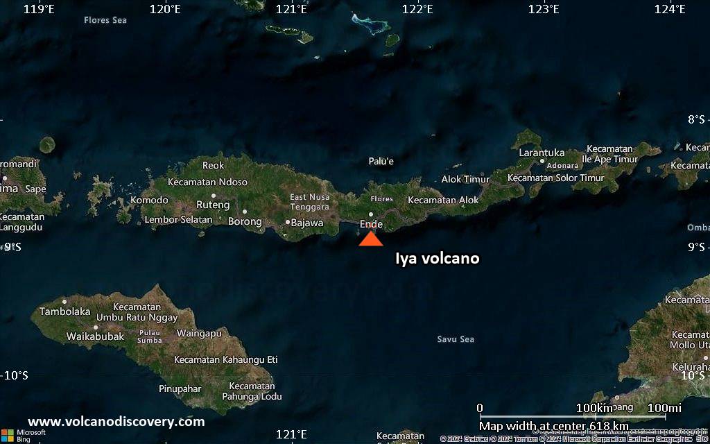
Explosive activity continues. Volcanic Ash Advisory Center (VAAC) Darwin warned about a volcanic ash plume that rose up to estimated 3000 ft (900 m) altitude or flight level 030 and is moving at 10 kts in NW direction. The full report is as follows:
FVAU04 at 06:43 UTC, 01/05/26 from ADRM VA ADVISORY DTG: 20260501/0643Z VAAC: DARWIN VOLCANO: IYA 264110 PSN: S0853 E12138 AREA: INDONESIA SOURCE ELEV: 618M AMSL ADVISORY NR: 2026/1 INFO SOURCE: CVGHM, HIMAWARI-9 ERUPTION DETAILS: VA TO FL030 REPORTED AT 01/0513Z EST VA DTG: 01/0620Z EST VA CLD: SFC/FL030 S0857 E12138 – S0852 E12133 – S0846 E12134 – S0847 E12140 – S0854 E12142 MOV NW 10KT FCST VA CLD +6 HR: 01/1220Z NO VA EXP FCST VA CLD +12 HR: 01/1820Z NO VA EXP FCST VA CLD +18 HR: 02/0020Z NO VA EXP RMK: MINOR VA EMISSION REPORTED IN CVGHM VONA AT 01/0513Z. VA NOT IDENTIFIABLE ON SATELLITE IMAGERY DUE TO MET CLOUD. HEIGHT AND MOVEMENT BASED ON GROUND REPORT AND MODEL GUIDANCE. NXT ADVISORY: NO LATER THAN 20260501/1243Z=
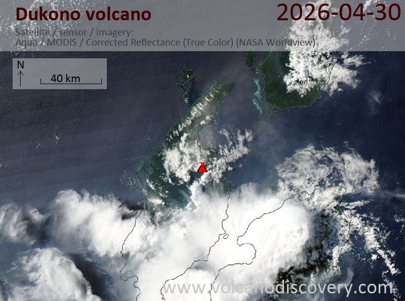
Explosive activity continues. Volcanic Ash Advisory Center (VAAC) Darwin warned about a volcanic ash plume that rose up to estimated 7000 ft (2100 m) altitude or flight level 070 . The full report is as follows:
FVAU03 at 00:59 UTC, 01/05/26 from ADRM VA ADVISORY DTG: 20260501/0100Z VAAC: DARWIN VOLCANO: DUKONO 268010 PSN: N0142 E12754 AREA: INDONESIA SOURCE ELEV: 1229M AMSL ADVISORY NR: 2026/185 INFO SOURCE: HIMAWARI-9, CVGHM ERUPTION DETAILS: VA TO FL070 OBS AT 01/0040Z MOV N OBS VA DTG: 01/0040Z OBS VA CLD: SFC/FL070 N0135 E12759 – N0135 E12749 – N0220 E12725 – N0314 E12749 – N0308 E12823 MOV N 05KT FCST VA CLD +6 HR: 01/0640Z SFC/FL070 N0144 E12743 – N0222 E12759 – N0216 E12832 – N0146 E12836 – N0131 E12752 FCST VA CLD +12 HR: 01/1240Z SFC/FL070 N0145 E12743 – N0234 E12818 – N0222 E12855 – N0144 E12853 – N0131 E12752 FCST VA CLD +18 HR: 01/1840Z SFC/FL070 N0145 E12743 – N0240 E12811 – N0214 E12858 – N0126 E12850 – N0131 E12752 RMK: CONTINUOUS VA IDENTIFIABLE ON SATELLITE IMAGERY. VA HEIGHT AND MOVEMENT BASED ON SATELLITE IMAGERY AND MODEL GUIDANCE. NXT ADVISORY: NO LATER THAN 20260501/0700Z=
Explosive activity continues. Volcanic Ash Advisory Center (VAAC) Washington warned about a volcanic ash plume that rose up to estimated 20000 ft (6100 m) altitude or flight level 200 . The full report is as follows:
FVXX24 at 00:18 UTC, 01/05/26 from KNES VA ADVISORY DTG: 20260501/0015Z
RMK: VA PLUME DRIFTING SW IS STARTING TO MOV MORE S. VA EMS OBS IN STLT IMAGERY AND WEBCAM APPRX 50NM SSW FM SUMMIT. VA FCST THRU T+18 HRS BASED ON RCNT STLT IMAGERY. NWP MDLS SUGGEST LGT/VRBL FL WIND. …COVERDALE
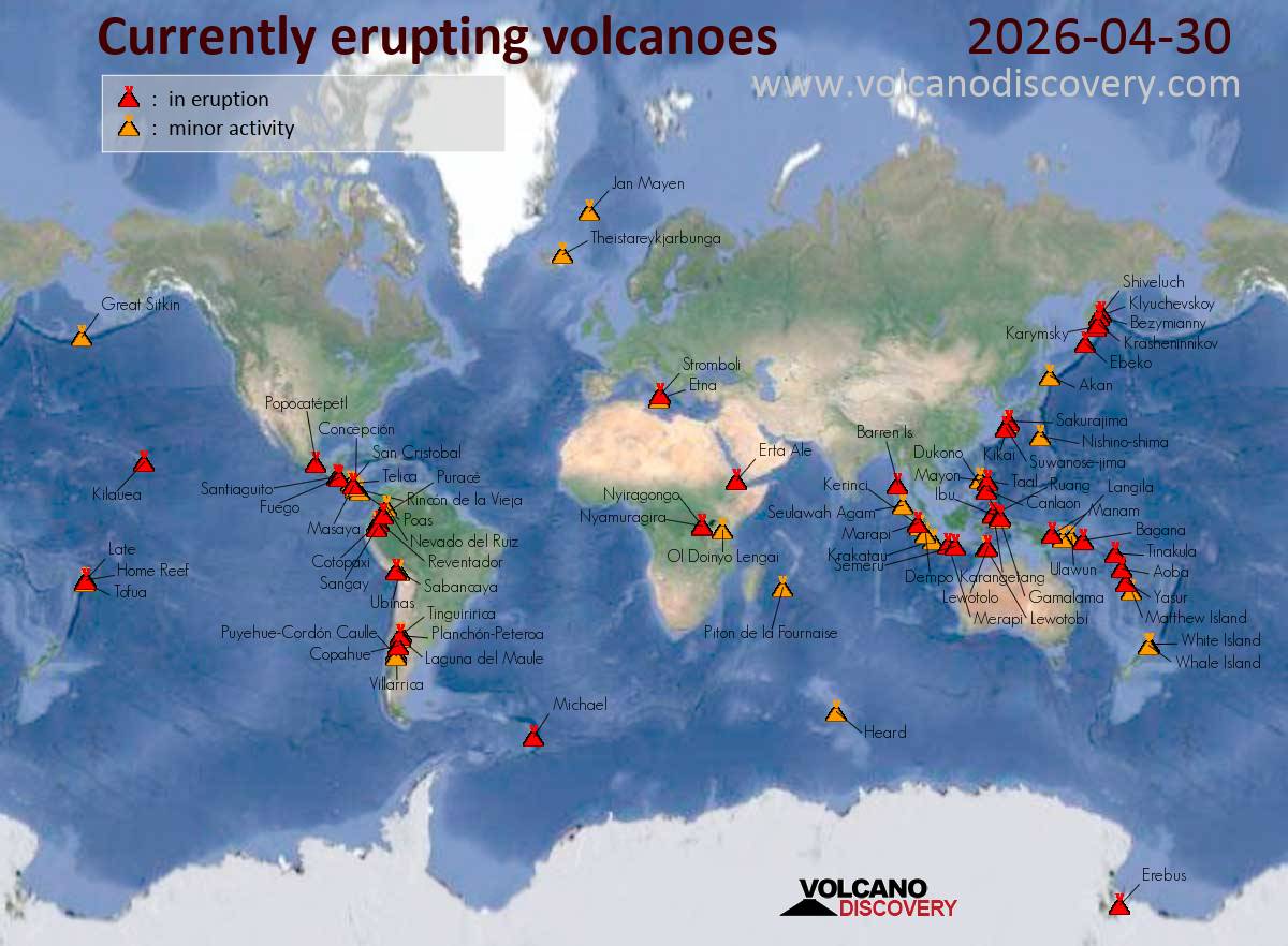
Canlaon (Central Philippines): The Philippine Institute of Volcanology and Seismology (PHIVOLCS) reported that the eruption continued at Kanlaon on 29 April 2026 (local). Tremor episodes were recorded 1 times. Volcanic seismicity was recorded 4 times. Sulfur dioxide (SO₂) emissions averaged 974 tonnes per day on 29 April. The alert level remained at „2 – Moderate Level of Volcanic Unrest“ (on a 0–5 level scale). Activity also included: inflationary deformation, tremor, volcanic seismicity. Source: Philippine Institute of Volcanology and Seismology (PHIVOLCS) … [read more] … [show less] Current Alerts: Observatory alert level: „2 – Moderate Level of Volcanic Unrest“ (on a 0–5 level scale)
Taal (Luzon, Philippines): The Philippine Institute of Volcanology and Seismology (PHIVOLCS) reported that the eruption continued at Taal on 29 April 2026 (local). There were 3 phreatic explosions reported. Tremor episodes were recorded 5 times. Sulfur dioxide (SO₂) emissions averaged 858 tonnes per day on 29 April. The alert level remained at „1 – Low-Level Unrest“ (on a 0–5 level scale). Activity also included: inflationary deformation, tremor. Source: Philippine Institute of Volcanology and Seismology (PHIVOLCS) … [read more] … [show less] Current Alerts: Observatory alert level: „1 – Low-Level Unrest“ (on a 0–5 level scale)
Mayon (Luzon Island, Philippines): The Philippine Institute of Volcanology and Seismology (PHIVOLCS) reported that the eruption continued at Mayon on 29 April 2026 (local). Lava effusion continued from the summit crater. As of 29 April, lava flow lengths remained at 3.8 km in the Basud Gully (E flank), 3.2 km in the Bonga Gully (SE flank), and 1.6 km in the Mi-isi Gully (S flank). Minor episodic Strombolian activity was observed. Short-lived lava fountaining was observed. Plume(s) rose to a maximum of 300 m (984 ft) above the vent. Volcanic seismicity was recorded 45 times. Tremor episodes were recorded 32 times. There were 307 seismically detected rockfalls. Crater glow was visible to the naked eye. Sulfur dioxide (SO₂) emissions averaged 2,087 tonnes per day on 29 April. Ground deformation indicated short-term deflation across the volcanic edifice, with shorter-term inflation localized on the NE flank. The alert level remained at „3 – Increased Tendency Towards Hazardous Eruption“ (on a 0–5 level scale). Activity also included: tremor, volcanic seismicity. Source: Philippine Institute of Volcanology and Seismology (PHIVOLCS) … [read more] … [show less] Current Alerts: Observatory alert level: „3 – Increased Tendency Towards Hazardous Eruption“ (on a 0–5 level scale)
Bulusan (Luzon Island, Philippines): The Philippine Institute of Volcanology and Seismology (PHIVOLCS) reported that unrest continued at Bulusan on 29 April 2026 (local). Plume(s) rose to a maximum of 50 m (164 ft) above the vent. Volcanic seismicity was recorded 127 times. The alert level remained at „1 – Low Level of Volcanic Unrest“ (on a 0–5 level scale). Activity also included: inflationary deformation, volcanic seismicity. Source: Philippine Institute of Volcanology and Seismology (PHIVOLCS) … [read more] … [show less] Current Alerts: Observatory alert level: „1 – Low Level of Volcanic Unrest“ (on a 0–5 level scale)
Gamalama (Halmahera): The Center for Volcanology and Geological Hazard/Pusat Vulkanologi dan Mitigasi Bencana Geologi (CVGHM/PVMBG) reported that unrest continued at Gamalama on 29 April 2026 (local). Gas and vapor plume(s) rose to a maximum of 100 m (328 ft) above the vent. The alert level remained at „Level 2 – Alert“ (on a 4-level scale). Source: Center for Volcanology and Geological Hazard/Pusat Vulkanologi dan Mitigasi Bencana Geologi (CVGHM/PVMBG) … [read more] … [show less] Current Alerts: Observatory alert level: „Level 2 – Alert“ (on a 4-level scale)
Ibu (Halmahera, Indonesia): The Center for Volcanology and Geological Hazard/Pusat Vulkanologi dan Mitigasi Bencana Geologi (CVGHM/PVMBG) reported that the eruption continued at Ibu on 29 April 2026 (local). Gas and vapor plume(s) rose to a maximum of 200 m (656 ft) above the vent. There were 116 explosions reported, with plumes rising to a maximum of 500 m (1,640 ft) above the vent. There was 1 seismically detected rockfall. The alert level remained at „Level 2 – Alert“ (on a 4-level scale). Source: Center for Volcanology and Geological Hazard/Pusat Vulkanologi dan Mitigasi Bencana Geologi (CVGHM/PVMBG) … [read more] … [show less] Current Alerts: Observatory alert level: „Level 2 – Alert“ (on a 4-level scale)
Lewotobi (Flores): The Center for Volcanology and Geological Hazard/Pusat Vulkanologi dan Mitigasi Bencana Geologi (CVGHM/PVMBG) reported that the eruption continued at Lewotobi (Laki-Laki) on 29 April 2026 (local). Gas and vapor plume(s) rose to a maximum of 100 m (328 ft) above the vent. The alert level remained at „Level 2 – Alert“ (on a 4-level scale). Source: Center for Volcanology and Geological Hazard/Pusat Vulkanologi dan Mitigasi Bencana Geologi (CVGHM/PVMBG) … [read more] … [show less] Current Alerts: Observatory alert level: „Level 2 – Alert“ (on a 4-level scale)
Lewotolo (Lesser Sunda Islands): The Center for Volcanology and Geological Hazard/Pusat Vulkanologi dan Mitigasi Bencana Geologi (CVGHM/PVMBG) reported that the eruption continued at Lewotolok on 29 April 2026 (local). Ash and gas plume(s) rose to a maximum of 100 m (328 ft) above the vent. There were 45 seismically detected explosions reported. Faint to moderate rumbling sounds were reported. There were 3 seismically detected rockfalls. The alert level remained at „Level 2 – Alert“ (on a 4-level scale). Source: Center for Volcanology and Geological Hazard/Pusat Vulkanologi dan Mitigasi Bencana Geologi (CVGHM/PVMBG) … [read more] … [show less] Current Alerts: Observatory alert level: „Level 2 – Alert“ (on a 4-level scale)
Krakatau (Sunda Strait, Indonesia): The Center for Volcanology and Geological Hazard/Pusat Vulkanologi dan Mitigasi Bencana Geologi (CVGHM/PVMBG) reported that unrest continued at Krakatau on 29 April 2026 (local). The alert level remained at „Level 2 – Alert“ (on a 4-level scale). Source: Center for Volcanology and Geological Hazard/Pusat Vulkanologi dan Mitigasi Bencana Geologi (CVGHM/PVMBG) … [read more] … [show less] Current Alerts: Observatory alert level: „Level 2 – Alert“ (on a 4-level scale)
Merapi (Central Java, Indonesia): The Center for Volcanology and Geological Hazard/Pusat Vulkanologi dan Mitigasi Bencana Geologi (CVGHM/PVMBG) reported that the eruption continued at Merapi on 29 April 2026 (local). Gas and vapor plume(s) rose to a maximum of 300 m (984 ft) above the vent. There were 20 hot rockfalls, traveling up to 2,000 m. There were 154 seismically detected rockfalls. The alert level remained at „Level 3 – Standby“ (on a 4-level scale). Source: Center for Volcanology and Geological Hazard/Pusat Vulkanologi dan Mitigasi Bencana Geologi (CVGHM/PVMBG) … [read more] … [show less] Current Alerts: Observatory alert level: „Level 3 – Standby“ (on a 4-level scale)
Semeru (East Java, Indonesia): The Center for Volcanology and Geological Hazard/Pusat Vulkanologi dan Mitigasi Bencana Geologi (CVGHM/PVMBG) reported that the eruption continued at Semeru on 29 April 2026 (local). There were 71 explosions reported, with plumes rising to a maximum of 600 m (1,969 ft) above the vent. There were 2 seismically detected rockfalls. The alert level remained at „Level 3 – Standby“ (on a 4-level scale). Source: Center for Volcanology and Geological Hazard/Pusat Vulkanologi dan Mitigasi Bencana Geologi (CVGHM/PVMBG) … [read more] … [show less] Current Alerts: Observatory alert level: „Level 3 – Standby“ (on a 4-level scale)
Marapi (Western Sumatra, Indonesia): The Center for Volcanology and Geological Hazard/Pusat Vulkanologi dan Mitigasi Bencana Geologi (CVGHM/PVMBG) reported that the eruption continued at Marapi on 29 April 2026 (local). The alert level remained at „Level 2 – Alert“ (on a 4-level scale). Source: Center for Volcanology and Geological Hazard/Pusat Vulkanologi dan Mitigasi Bencana Geologi (CVGHM/PVMBG) … [read more] … [show less] Current Alerts: Observatory alert level: „Level 2 – Alert“ (on a 4-level scale)
Dukono (Halmahera): The Center for Volcanology and Geological Hazard/Pusat Vulkanologi dan Mitigasi Bencana Geologi (CVGHM/PVMBG) reported that the eruption continued at Dukono on 29 April 2026 (local). There were 87 explosions reported, with plumes rising to a maximum of 1,200 m (3,937 ft) above the vent. The alert level remained at „Level 2 – Alert“ (on a 4-level scale). Source: Center for Volcanology and Geological Hazard/Pusat Vulkanologi dan Mitigasi Bencana Geologi (CVGHM/PVMBG) … [read more] … [show less] Current Alerts: Observatory alert level: „Level 2 – Alert“ (on a 4-level scale)
Kerinci (Sumatra): The Center for Volcanology and Geological Hazard/Pusat Vulkanologi dan Mitigasi Bencana Geologi (CVGHM/PVMBG) reported that unrest continued at Kerinci on 29 April 2026 (local). Gas and vapor plume(s) rose to a maximum of 200 m (656 ft) above the vent. Tremor episodes were recorded 1 times. The alert level remained at „Level 2 – Alert“ (on a 4-level scale). Activity also included: tremor. Source: Center for Volcanology and Geological Hazard/Pusat Vulkanologi dan Mitigasi Bencana Geologi (CVGHM/PVMBG) … [read more] … [show less] Current Alerts: Observatory alert level: „Level 2 – Alert“ (on a 4-level scale)
Kilauea (Hawai’i): The United States Geological Survey – Hawaiian Volcano Observatory (USGS-HVO) reported that there was a pause in eruptive activity at Kilauea between 28 April 2026 (local) and 29 April 2026 (local). Webcam footage captured consistent glow from both the north and south vents overnight, although glow from the south vent appeared notably brighter. Over the past day, seismicity at the summit increased, with 96 small earthquakes recorded (all below M2.0), primarily occurring within Halemaʻumaʻu Crater and to the S and SW of the caldera. Both the north and south vents sometimes produced flames. The alert level remained at „Advisory“ (level 2 on a 4-level scale). The aviation alert level remained at „Yellow“ (level 2 on a 4-level scale). Source: United States Geological Survey – Hawaiian Volcano Observatory (USGS-HVO) … [read more] … [show less] Current Alerts: Observatory alert level: „Advisory“ (level 2 on a 4-level scale)
Shishaldin (Aleutian Islands, Alaska): The United States Geological Survey – Alaska Volcano Observatory (USGS-AVO) reported that unrest continued at Shishaldin between 28 April 2026 (local) and 29 April 2026 (local). The alert level remained at „Advisory“ (level 2 on a 4-level scale). The aviation alert level remained at „Yellow“ (level 2 on a 4-level scale). Source: United States Geological Survey – Alaska Volcano Observatory (USGS-AVO) … [read more] … [show less] Current Alerts: Observatory alert level: „Advisory“ (level 2 on a 4-level scale)
Great Sitkin (United States, Aleutian Islands): The United States Geological Survey – Alaska Volcano Observatory (USGS-AVO) reported that the eruption continued at Great Sitkin between 28 April 2026 (local) and 29 April 2026 (local). Lava continued to slowly erupt in the summit crater. Rockfalls generated by the growing lava dome were seismically recorded. The alert level remained at „Watch“ (level 3 on a 4-level scale). The aviation alert level remained at „Orange“ (level 3 on a 4-level scale). Source: United States Geological Survey – Alaska Volcano Observatory (USGS-AVO) … [read more] … [show less] Current Alerts: Observatory alert level: „Watch“ (level 3 on a 4-level scale)
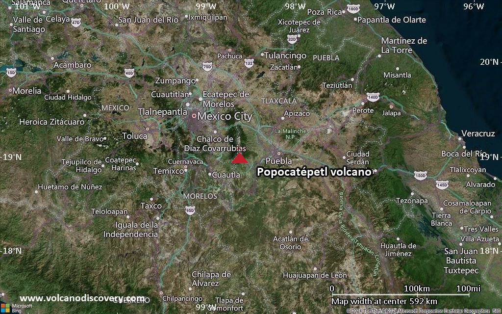
Popocatépetl (Central Mexico): The Centro Nacional de Prevención de Desastres (CENAPRED) reported that the eruption continued at Popocatépetl between 28 April 2026 (local) and 29 April 2026 (local). A total of 134 low-intensity exhalations were documented, in addition to exhalation sequences totaling 133 minutes in duration. During some of the exhalation sequences, incandescent fragments were ejected a short distance from the crater. Plumes of ash, gas, and steam accompanied the exhalations. On the morning of 29 April, The State Coordination of Civil Protection in Morelos reported minor ash fall in Tetela del Volcán (18 km SW). The alert level remained at „Yellow Alert – Phase 2“ (level 4 on a 7-level scale). Source: Centro Nacional de Prevención de Desastres (CENAPRED) … [read more] … [show less] Current Alerts: Observatory alert level: „Yellow Alert – Phase 2“ (level 4 on a 7-level scale)
Santiaguito (Guatemala): The Instituto Nacional de Sismología, Vulcanología, Meteorología e Hidrología (INSIVUMEH) reported that the eruption continued at Santa María between 28 April 2026 (local) and 29 April 2026 (local). A second episode of PDCs began around 1400 on 28 April, with PDCs continuing to extend to the base of the Caliente Dome (2,000–4,000 m). Ash from PDCs dispersed as far as 100 km to the SW and W. Increases in Real-time Seismic-Amplitude Measurement (RSAM) data were recorded during the PDC events. There were explosions reported, occurring at a rate of up to 3 per hour with plumes rising to a maximum of 3,400 m (11,155 ft) above sea level. Gas and vapor plume(s) rose to a maximum of 500 m (1,640 ft) above the vent. Source: Instituto Nacional de Sismología, Vulcanología, Meteorología e Hidrología (INSIVUMEH) … [read more] … [show less] Current Alerts: Observatory alert level: unavailable or not collected
Pacaya (Guatemala): The Instituto Nacional de Sismología, Vulcanología, Meteorología e Hidrología (INSIVUMEH) reported that unrest continued at Pacaya between 28 April 2026 (local) and 29 April 2026 (local). Activity also included: fumarolic activity. Source: Instituto Nacional de Sismología, Vulcanología, Meteorología e Hidrología (INSIVUMEH) … [read more] … [show less] Current Alerts: Observatory alert level: unavailable or not collected
Fuego (Guatemala): Volcanic Ash Advisory Center Washington (VAAC) issued the following report: VA EMS LIKELY ONGOING …30 Apr: The Instituto Nacional de Sismología, Vulcanología, Meteorología e Hidrología (INSIVUMEH) reported that the eruption continued at Fuego between 28 April 2026 (local) and 29 April 2026 (local). There were explosions reported, occurring at a rate of up to 13 per hour, with plumes rising to a maximum of 1,037 m (3,402 ft) above the vent. At night, incandescent material was ejected in pulses above the crater. There were incandescent rockfalls. Fine ash fall was reported in Panimaché Uno and Panimaché Dos, Finca La Asunción, Morelia, and El Porvenir. Gas and vapor plume(s) rose to a maximum of 537 m (1,762 ft) above the vent. Activity also included: audible sounds (e.g., booms, rumbling), shockwave. Source: Instituto Nacional de Sismología, Vulcanología, Meteorología e Hidrología (INSIVUMEH) … [read more] … [show less] Current Alerts: Observatory alert level: unavailable or not collected
Turrialba (Costa Rica): The Observatorio Vulcanológico y Sismológico de Costa Rica – Universidad Nacional (OVSICORI-UNA) reported that unrest continued at Turrialba between 28 April 2026 (local) and 29 April 2026 (local). The alert level remained at „Level 2 – Warning“ (on a 0–4 level scale). The aviation alert level remained at „Yellow“ (level 2 on a 4-level scale). Source: Observatorio Vulcanológico y Sismológico de Costa Rica – Universidad Nacional (OVSICORI-UNA) … [read more] … [show less] Current Alerts: Observatory alert level: „Level 2 – Warning“ (on a 0–4 level scale)
Rincón de la Vieja (Costa Rica): The Observatorio Vulcanológico y Sismológico de Costa Rica – Universidad Nacional (OVSICORI-UNA) reported that unrest continued at Rincón de la Vieja between 28 April 2026 (local) and 29 April 2026 (local). The alert level remained at „Level 2 – Warning“ (on a 0–4 level scale). The aviation alert level remained at „Yellow“ (level 2 on a 4-level scale). Source: Observatorio Vulcanológico y Sismológico de Costa Rica – Universidad Nacional (OVSICORI-UNA) … [read more] … [show less] Current Alerts: Observatory alert level: „Level 2 – Warning“ (on a 0–4 level scale)
Poas (Costa Rica): The Observatorio Vulcanológico y Sismológico de Costa Rica – Universidad Nacional (OVSICORI-UNA) reported that the eruption continued at Poás between 28 April 2026 (local) and 29 April 2026 (local). The alert level remained at „Level 2 – Warning“ (on a 0–4 level scale). The aviation alert level remained at „Yellow“ (level 2 on a 4-level scale). Source: Observatorio Vulcanológico y Sismológico de Costa Rica – Universidad Nacional (OVSICORI-UNA) … [read more] … [show less] Current Alerts: Observatory alert level: „Level 2 – Warning“ (on a 0–4 level scale)
Sangay (Ecuador): The Instituto Geofísico-Escuela Politécnica Nacional (IG-EPN) reported that the eruption continued at Sangay between 28 April 2026 (local) and 29 April 2026 (local). There were 378 seismically detected explosions reported. Ash and gas plume(s) rose to a maximum of 1,800 m (5,906 ft) above the vent. There were incandescent rockfalls, descending 1,400 m below the crater. The alert level remained at „2 – Yellow“ (on a 4-level scale). Activity also included: thermal anomaly(ies). Source: Instituto Geofísico-Escuela Politécnica Nacional (IG-EPN) … [read more] … [show less] Current Alerts: Observatory alert level: „2 – Yellow“ (on a 4-level scale)
Reventador (Ecuador): The Instituto Geofísico-Escuela Politécnica Nacional (IG-EPN) reported that the eruption continued at Reventador between 28 April 2026 (local) and 29 April 2026 (local). There were 80 seismically detected explosions reported. Ash and gas plume(s) rose to a maximum of 1,600 m (5,249 ft) above the vent. On the morning of 29 April, a pyroclastic density current (PDC), or pyroclastic flow, was observed descending the SW flank. There were incandescent rockfalls, descending 1,000 m below the crater. The alert level remained at „3 – Orange“ (on a 4-level scale). Activity also included: thermal anomaly(ies). Source: Instituto Geofísico-Escuela Politécnica Nacional (IG-EPN) … [read more] … [show less] Current Alerts: Observatory alert level: „3 – Orange“ (on a 4-level scale)
Sabancaya (Peru): Volcanic Ash Advisory Center Buenos Aires (VAAC) issued the following report: UNABLE TO DETECT …30 Apr: The Centro Vulcanológico Nacional del Instituto Geofísico del Perú (CENVUL-IGP) reported that the eruption continued at Sabancaya between 28 April 2026 (local) and 29 April 2026 (local). Ash, gas, and vapor plume(s) rose to a maximum of 2,200 m (7,218 ft) above the vent. A total of 3 earthquakes related to the movement of magma and gases were recorded. Thermal anomalies were detected 4 times. The alert level remained at „Orange“ (level 3 on a 4-level scale). Activity also included: thermal anomaly(ies). Source: Centro Vulcanológico Nacional del Instituto Geofísico del Perú (CENVUL-IGP) … [read more] … [show less] Current Alerts: Observatory alert level: „Orange“ (level 3 on a 4-level scale)